This article is part 4 of 7 in my series on Victorian-Era newspaper engravings from New Zealand. To see the other parts please click here.
Scene on the Maungatua Range, West Taieri (1883)
64/118
New Zealand was already living ‘off the sheeps’ back’ by the 1880s, wool providing the single most important export earner. Sheep numbered almost 13 million in 1881, or some 26 animals to every New Zealander. (Today there are approximately 20 sheep per person.) The man in the engraving, presumably checking over some of his newly- shorn sheep, enjoyed few comforts in the simple hut in the background.
Mosgiel Woollen Factory (1875)
65/118
The first woollen mill in New Zealand commenced operations in 1871, being promoted by A. J. Burns, a son of the Rev. Thomas Burns, one of the leaders of the Otago settlement of 1848. In November 1873 a joint-stock company was formed to purchase the plant and property of Messrs A. J. Burns & Co., and from that time on traded as the Mosgiel Woollen Factory. In 1875 the mill employed some 80 persons and produced such goods as tweeds, blanketing, plaiding, plaids, shawls, hosiery and knitting yarns.
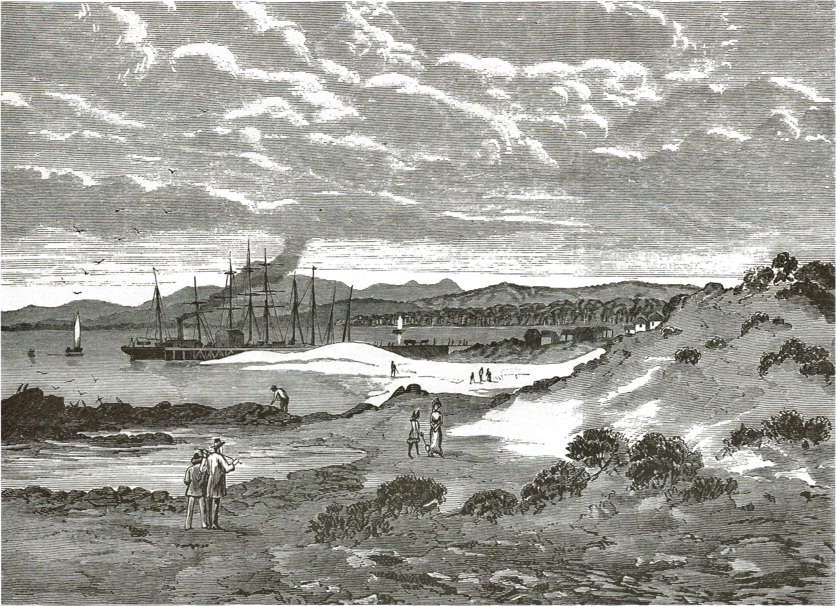
Otago Graving Dock (1870)
66/118
The dock at Port Chalmers, shown here under construction, was officially opened in March 1872. With a length of 91 metres (300 feet) and a width of 12.5 metres (41 feet) on the floor, it was able at the time of its completion to dock the largest vessel visiti New Zealand waters, but by the 1880s was too small, and was subsequently replaced by a larger dock.
Lyttelton Graving Dock (1881)
67/118
Commenced in 1879 and completed in 1882, the Lyttelton Graving Dock was 137 metres (450 feet) in length, and thus capable of servicing many of the newer and larger steamers that were then coming into service.
This article is part 3 of our 7-part series on Victorian-Era newspaper engravings in New Zealand. To see the other parts please click here.
This is a placeholder introduction to part 3 of 7, Rural life
53. Lake Wakatipu (1878)
The South Island lakes, known officially as the ‘Cold Lakes’ until complaints were made about the slur on southern weather, were part of the ‘Grand Tour’ for European visitors during the nineteenth century. The engraving was based on a sketch by John Gully.
54. Head of Lake McKerrow (1870)
This engraving must have given little encouragement to prospective settlers thinking of joining the Martin’s Bay Special Settlement. The Settlement was formed between Lake McKerrow and the sea in 1870, and many observers, such as R.P. Whitworth (who drew the original sketch) predicted that it would be successful, while admitting numerous difficulties would first have to be overcome. But the isolation of the area proved insurmountable, and the few families who located there abandoned their holdings, although one cattle run continued to be occupied until 1955.
55. Otago Heads from Portobello (1877)
A century ago city and town dwellers were as keen to get away to the coast or rural areas as today. The Illustrated New Zealand Herald commented that ‘The bays of the peninsula offer to excursionists of Dunedin, such inviting opportunities of thoroughly enjoying themselves that, if fine weather be given, a trip by the steamer down the harbour, past the various indents of the peninsula, is one of the most pleasurable, and at the same time cheapest modes of healthful recreation within easy reach of all classes of the people.’
56. Mt Roy, Lake Wanaka (1885)
In the earlier years of the settlement of New Zealand the height of the natural vegetation of an area was regarded as a reliable indicator of the quality of the soil. Thus all forest land was thought to be rich, and all grassland to be poor. Later in the nineteenth century the role of climate in determining vegetation was recognised. Many observers including scientists, however, were convinced that trees attracted rainfall, and suggested that such areas as shown here should be planted in trees.
57. Outside Milford Sound (1876)
John Gully’s drawing has captured the essence of an Australian reporter’s description of the South Island’s western coastline which he saw in 1861, along with thousands of Australian miners flocking to the Otago goldfields. The reporter wrote: ‘piled up in awful rows behind the precipitously rugged coast were tall mountains, whose snow capped tops, wreathed in feathery vapour, loomed from above the lower stratum of cloud that shrouded nearly all but the glistening white peaks. … The character of the coast had something sublimely terrible about it.’
58. Entrance to Grey River (1876)
The bar-bound Grey and other rivers proved a hazardous introduction to the West Coast for the miners who flocked there in 1865. Today the bar still limits the use of the Grey River as a port.
59. Akaroa and Banks Peninsula (1875)
Originally well-wooded, Banks Peninsula was rapidly being denuded of its timber by the mid-1870s, and farming was expanding. The scenes depicted clockwise from top left are the Church of England at Akaroa, South Head, a sawmill at Little River, Akaroa jetty, the Immigration Barracks, and Head of Bay. In the centre are shown Maori huts near Akaroa, and hanging beneath the food store can be seen sun-dried fish such as shark and eel.
60. Manawatu Gorge and Bridge (1877)
The Gorge was recommended as an interesting spot for the itinerant artist on a sketching tour because of the ‘beautiful scenery’ which ‘abounds in the neighbourhood’. In May 1875 the Gorge was bridged, opening up quicker communication between the Manawatu and Wairarapa. Built of totara and with a main span of over 49 metres (162 feet), tolls were charged for its use until 1907.
61. Scene on the Waikato River (1884)
Drawn from near the site of present-day Atiamuri, Mt Pohaturoa (520 metres, 1,705 feet) appears prominently on the skyline. This rocky pinnacle was the site of many lengthy sieges during the day of Maori inter-tribal warfare.
62. Mt Ngauruhoe, The Steaming Mountain in the North Island (1886)
The most active of New Zealand volcanoes, Ngauruhoe was first climbed in 1839 by the naturalist and explorer J. C. Bidwill. He described the crater as ‘the most terrific abyss I ever looked into or imagined. The rocks overhung it on all sides, and it was not possible to see above ten yards into it from the quantity of steam which it was continually discharging.’
63. The Pink Terrace (1884)
Regarded as one of the unique tourist attractions of New Zealand, the terraces were destroyed during the eruption of Mt Tarawera in 1886. It was possibly a case of ‘distance lends enchantment’, for one writer commented that the pink colour which seemed remarkably beautiful from a distance, proved often to be ‘rather a dirty white’ when seen close at hand. Vandals have long been with us, for the Maoris of the 1880s complained of the practice of tourists of carving their initials on the terraces.
In the second entry to our Victorian Engravings series, we take a look at some familar towns and cities in a way we have never seen them before
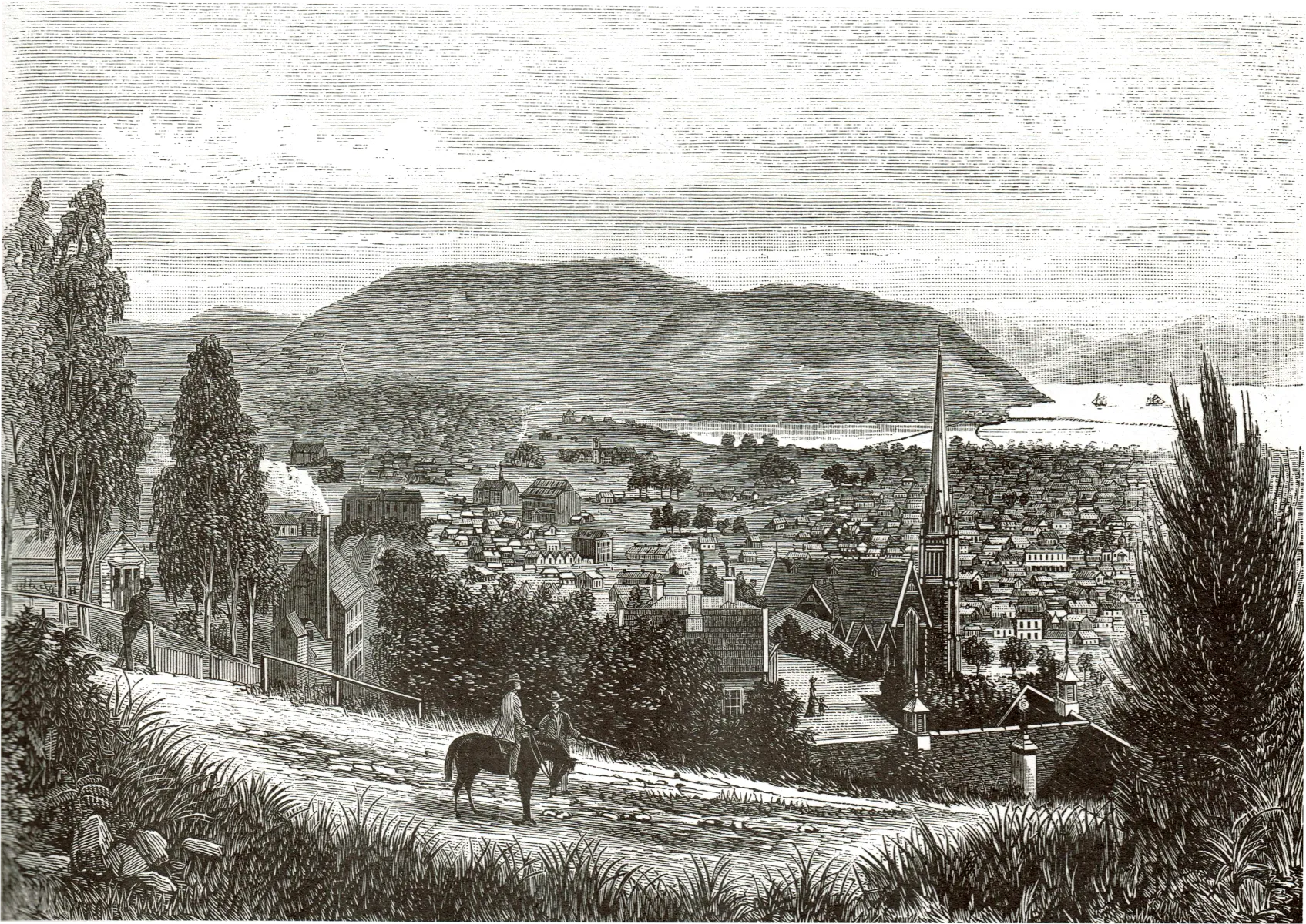
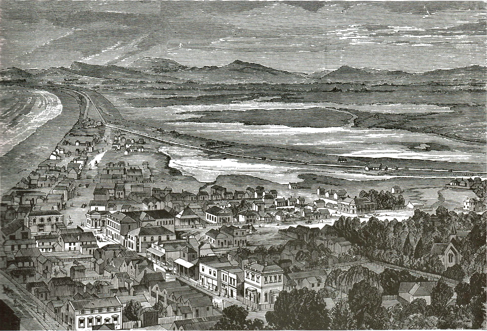
27. North Dunedin (1880)
Asa result of the goldrushes of the 1860s, Dunedin became the leading city of the Colony. A Dunedin correspondent, writing to the New Zealand Herald in 1874, commented that ‘socially considered, we of the South are a century behind you in the North; whilst commercially we are a century in advance of you.’ Prominent in the engraving is Knox Church, a symbol of Otago’s Presbyterian heritage. The Church, still in use today, was built in 1876, replacing an earlier church built in 1860 on a site a block away. Asa result of the goldrushes of the 1860s, Dunedin became the leading city of the Colony. A Dunedin correspondent, writing to the New Zealand Herald in 1874, commented that ‘socially considered, we of the South are a century behind you in the North; whilst commercially we are a century in advance of you.’ Prominent in the engraving is Knox Church, a symbol of Otago’s Presbyterian heritage. The Church, still in use today, was built in 1876, replacing an earlier church built in 1860 on a site a block away.
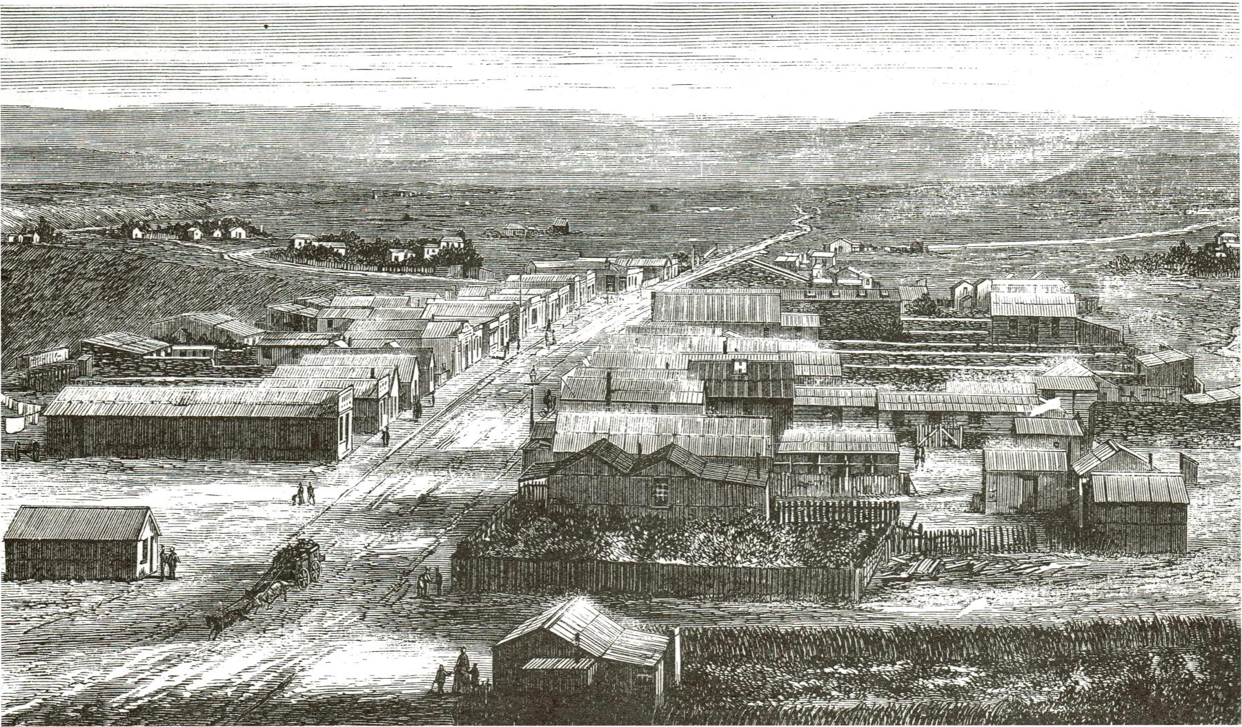
28. Invercargill (1884)
With a population of over four thousand in 1881, the Borough of Invercargill was known in Victorian New Zealand for its remarkably wide streets. With telephones yet to come, and light provided by gas, there was no necessity for the maze of wires and poles which typify our townscapes today. Even shop verandahs were not then compulsory.
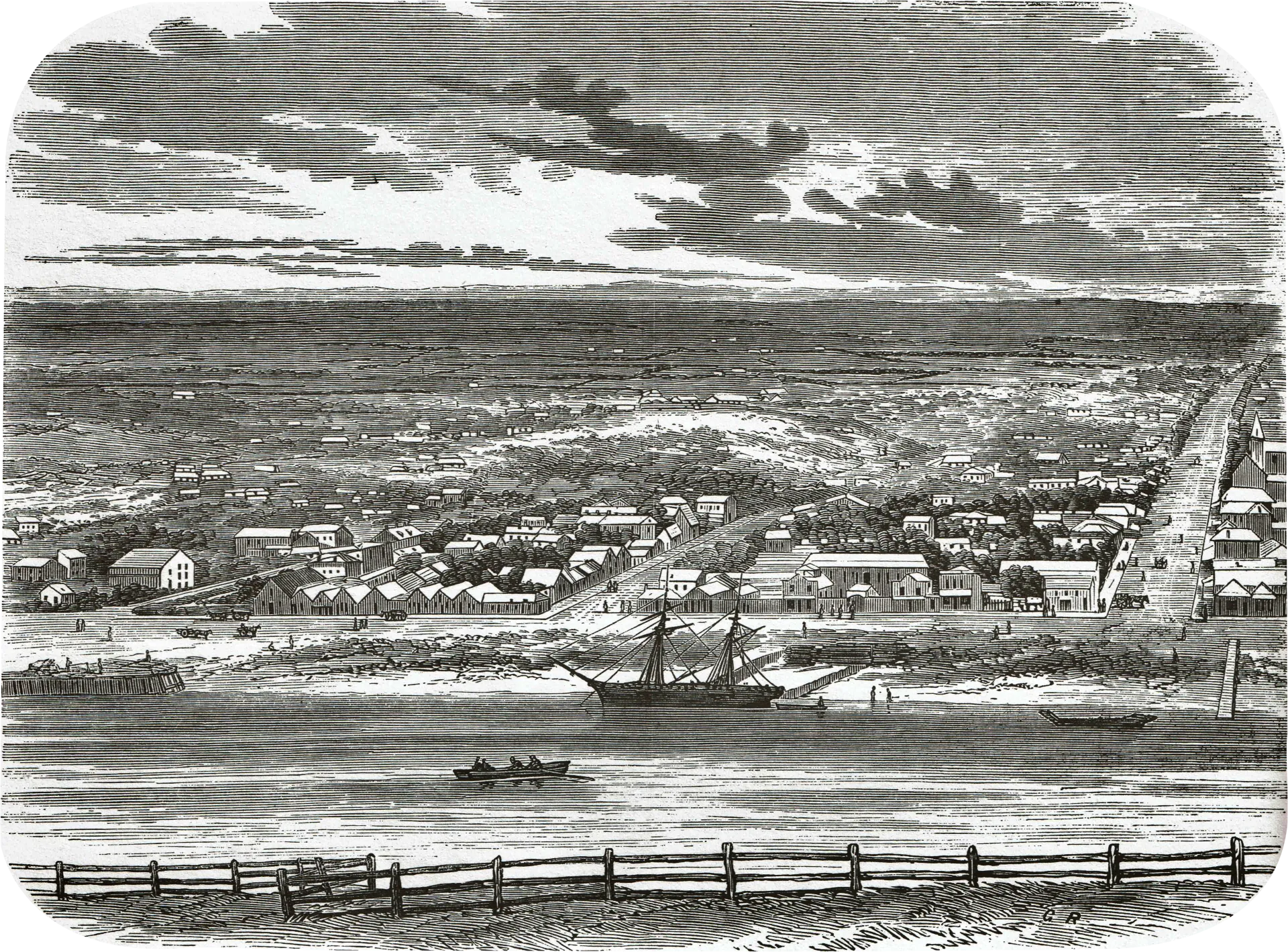
29. Bluff (1882)
The harbour at Bluff was described as accessible at all phases of the tide, but having a tortuous passage and ‘subject to baffling winds from the north.’ The township, then known as Campbelltown, had a population of some 350. The town reverted to the name of Bluff in 1917.
30. Clyde (1872)
A bustling, mining township of the 1860s, Clyde (formerly known as Dunstan or Hartley Township) had changed to a quiet country centre with the exhaustion of easily available alluvial gold in the neighbourhood. Clyde was proclaimed a municipality in 1866, and became the administrative centre of Vincent County when it was formed in 1876.
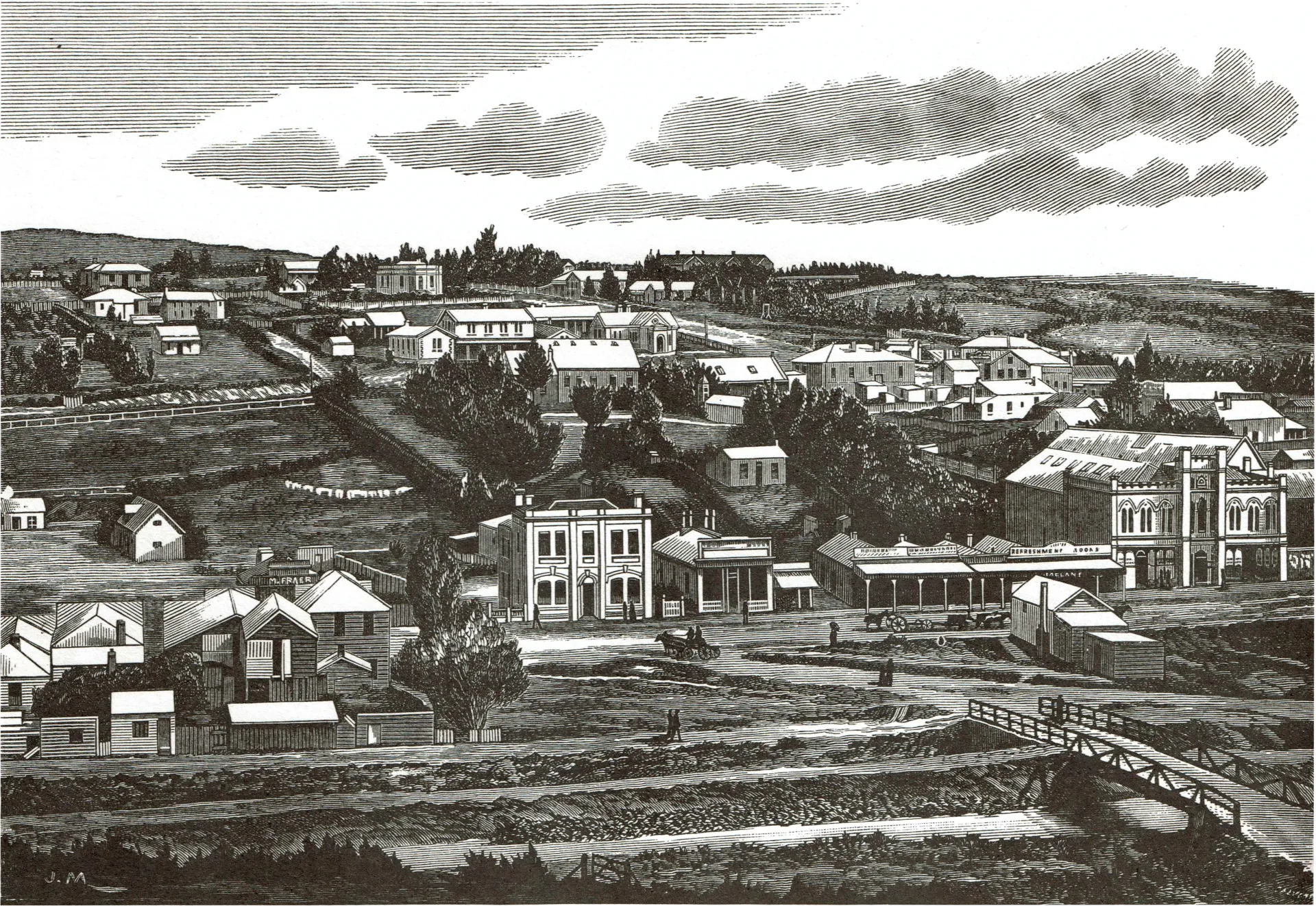
31. Lawrence (1885)
By the mid ‘eighties the Central Otago township of Lawrence had settled down to a placid rural existence. The hustle and bustle of the goldrushes of the early ‘sixties which had called Lawrence into being were but a memory, although gold sluicing was still carried on in nearby Gabriel’s Gully and elsewhere.
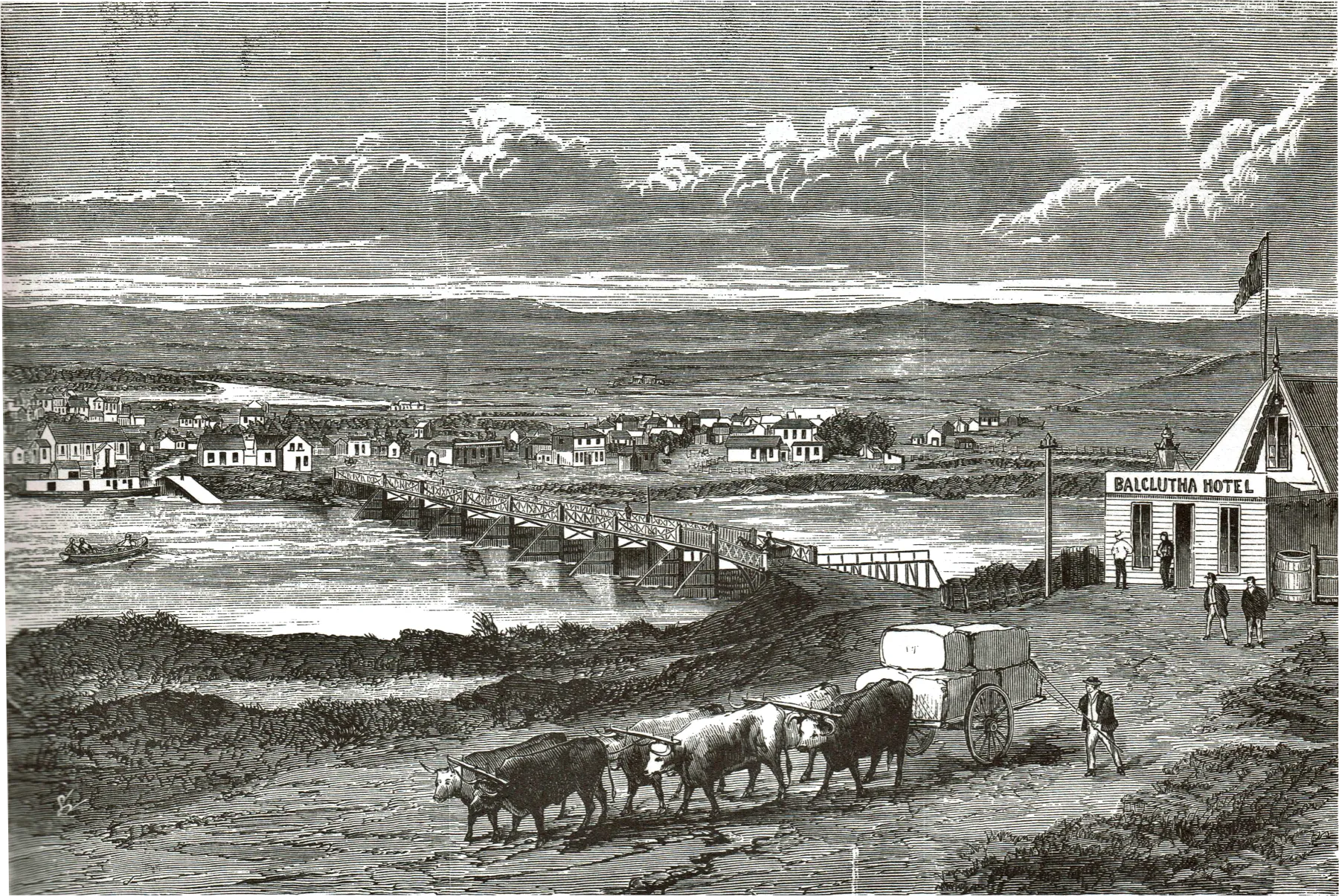
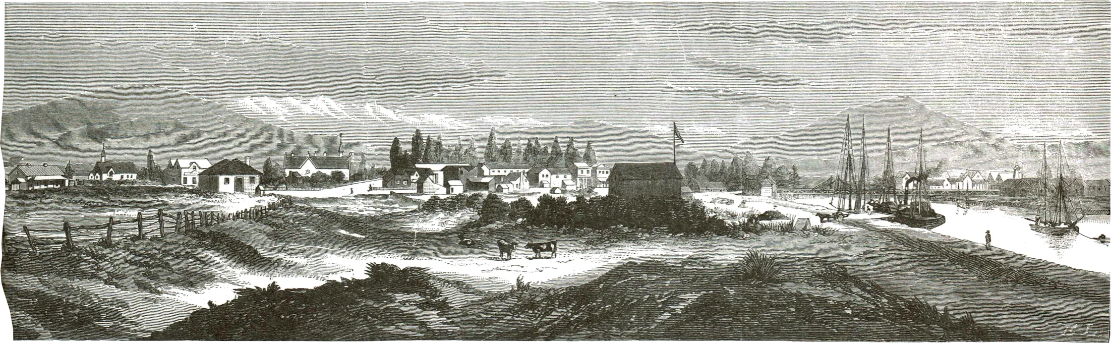
32. Balclutha (1872)
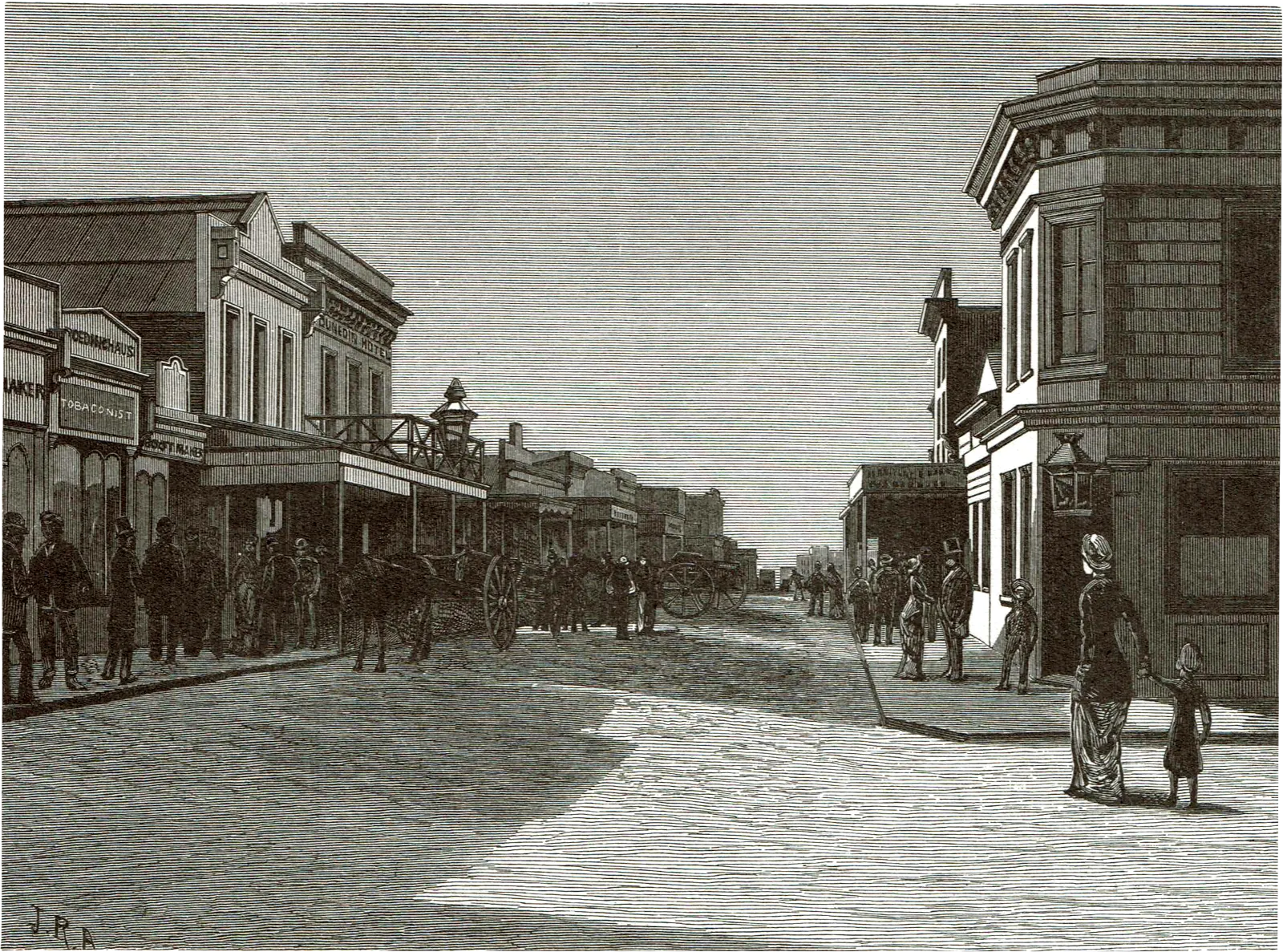
‘Situated on the finest and the most capable of the rivers of the colony, it is by no means chimerical to see in her the future commercial metropolis of this antipodean dependency of Britain.’ These were the high hopes of a writer in the Illustrated New Zealand Herald a century ago, hopes based on the strategic location of the town on the Clutha River. It is no reflection on Balclutha to say that this has not come to pass.
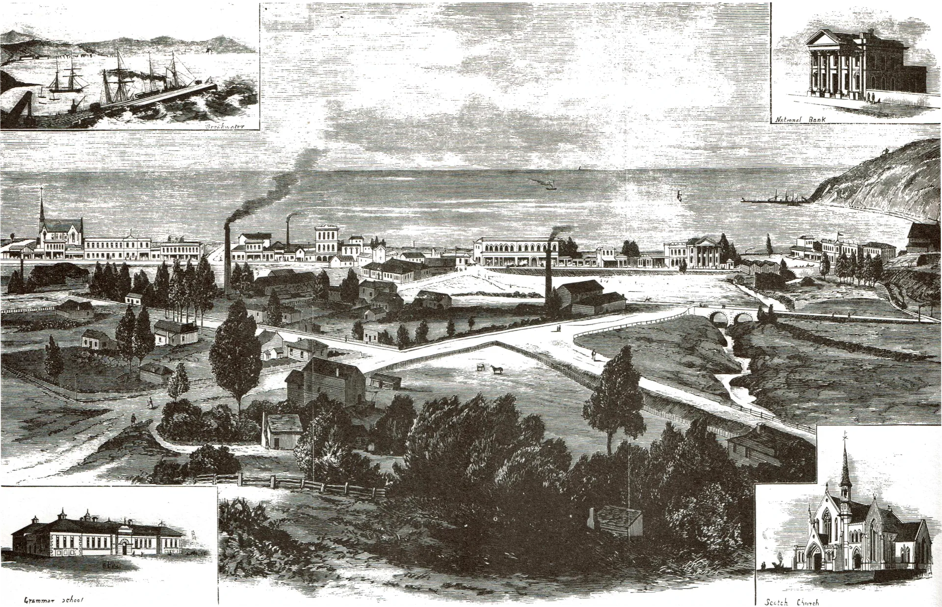
33. Oamaru (1877)
With nearly 5,000 inhabitants, Oamaru was the most important town of North Otago, and was well known for its many buildings constructed from locally- quarried white limestone. In its commentary on the engraving, the Illustrated New Zealand Herald proudly proclaimed the virtues of Oamaru’s climate saying that ‘anything like a continuance of cold or wet weather, even in the depth of winter (so called) is rarely known.’
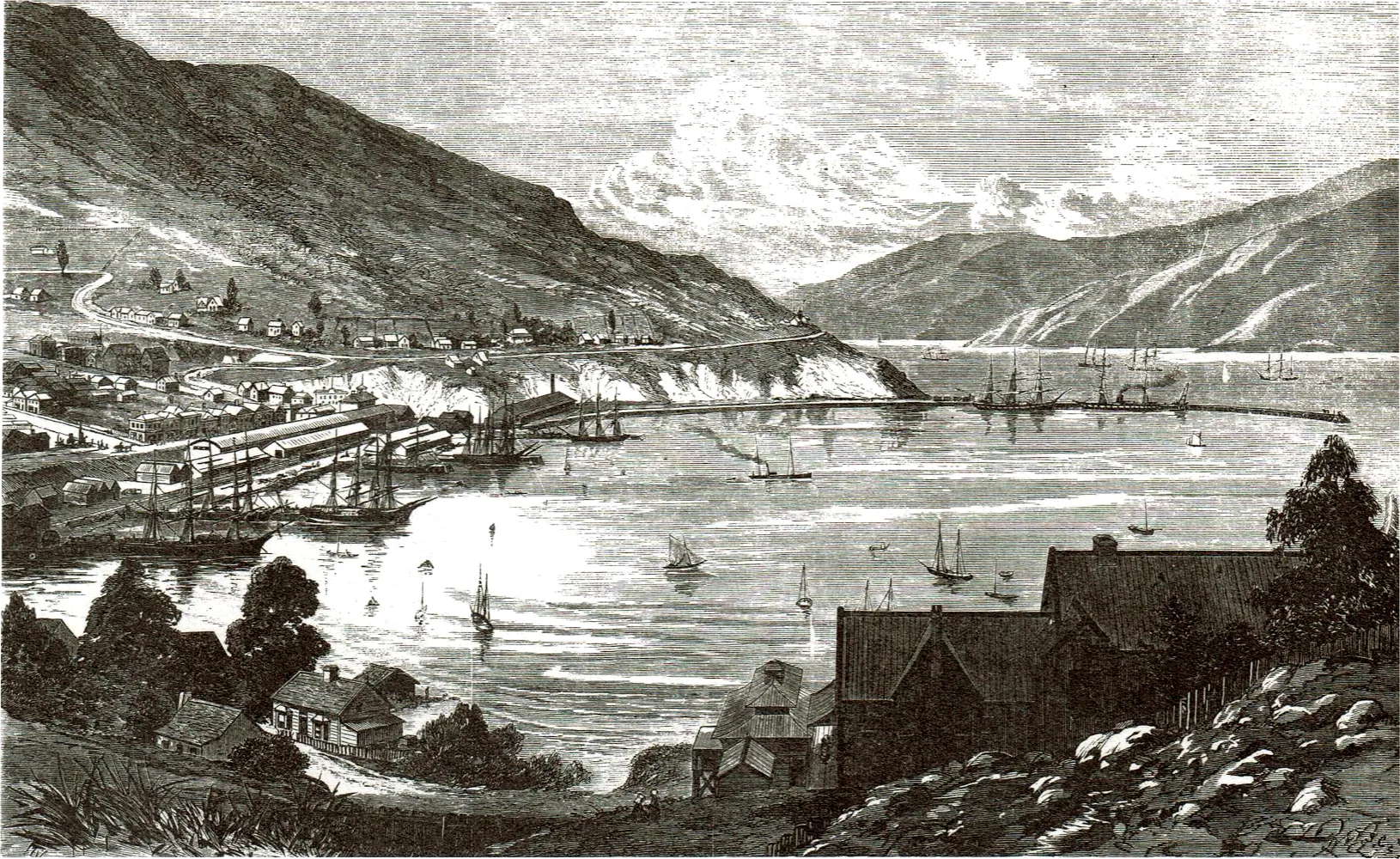
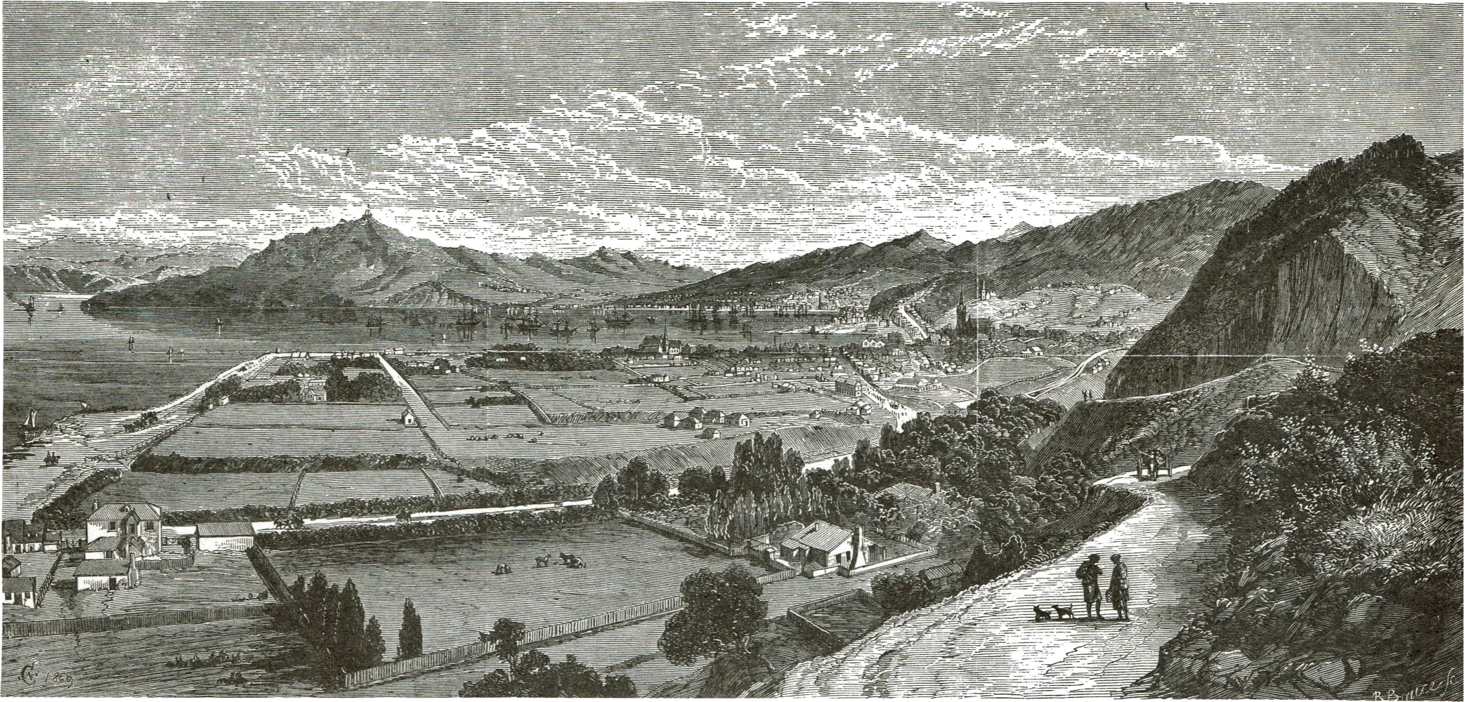
34. Lyttelton (1876)
In 1876 the port of Lyttelton was just beginning a period of major expansion. The second of two breakwaters was nearing completion, while between 1877 and 1881 six jetties were built.
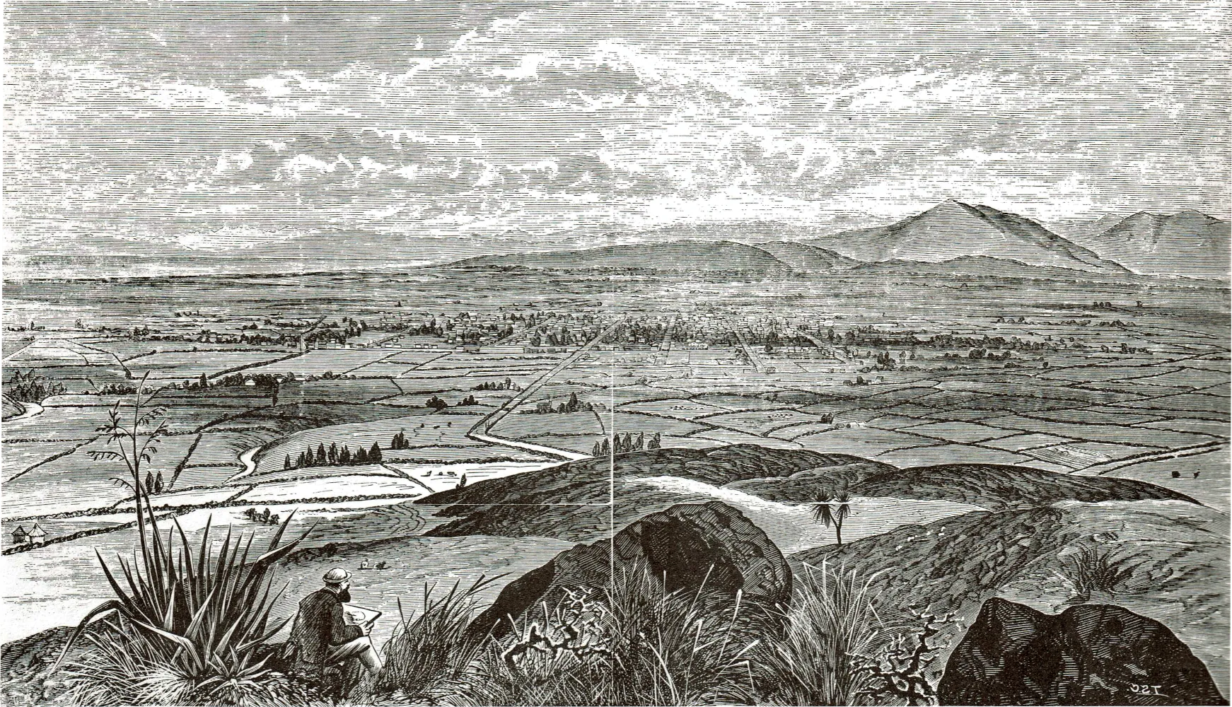
35. Christchurch on the Plains (1870)
Sketched from the Port Hills, the capital city of Canterbury Province stands amidst a checkerboard pattern of fields marked off by gorse hedges.
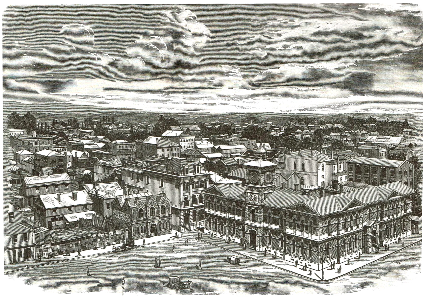
36. Christchurch from the Cathedral (1884)
The Square focal point of Christchurch, was an unhurried place last century, with pedestrians rather than traffic dominating the scene. The brick building with the tower is the Post Office, and this still continues to give character to the square today, though now dwarfed by more modern structures.
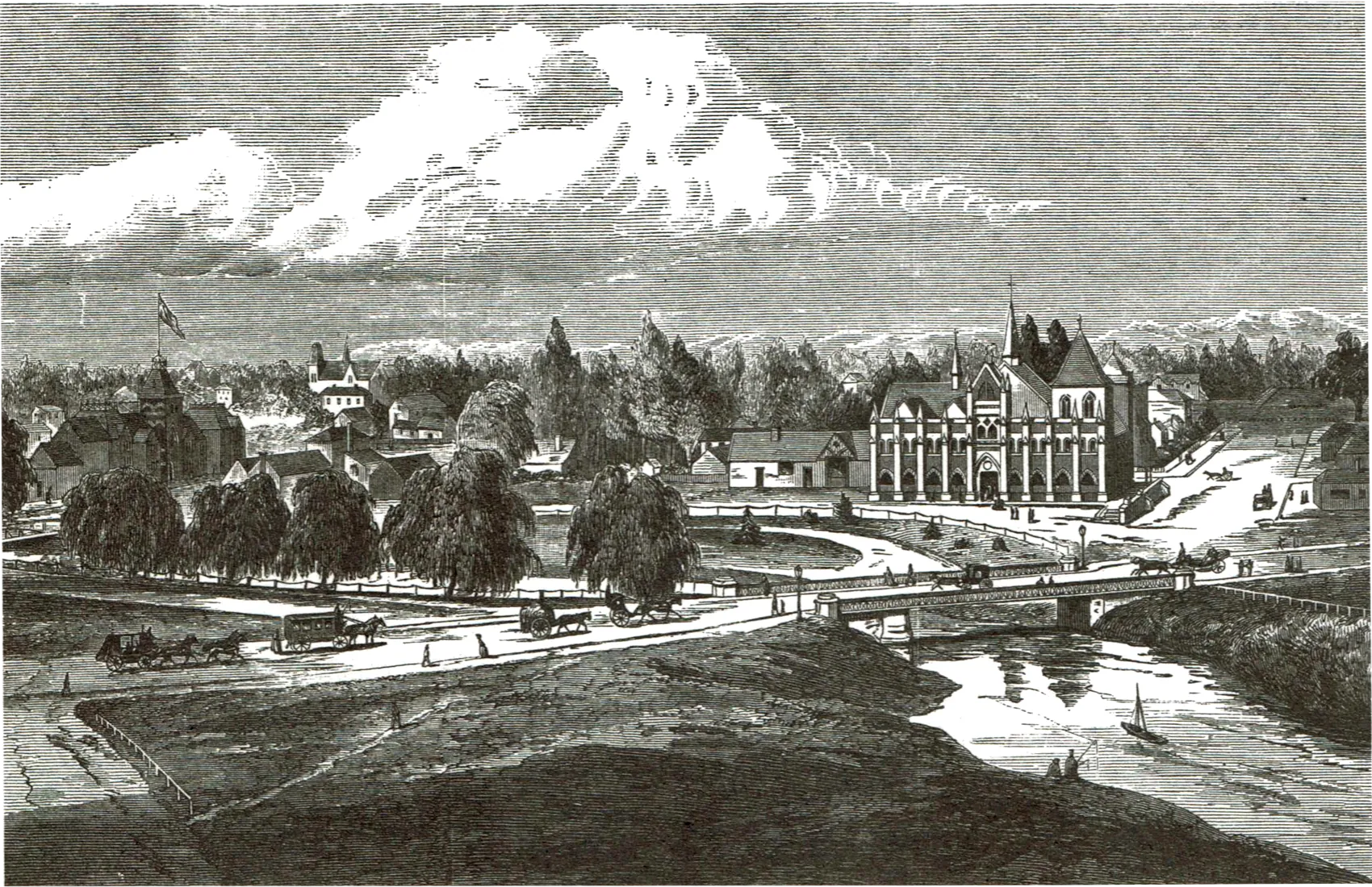
37. Christchurch (1877)
A century ago Christchurch was described as not possessing ‘the natural attractions of Dunedin’ nor presenting ‘such a scene of business bustle’, though it was recognised as ‘the most English-like city in the Colonies.’ In the foreground is the Victoria bridge, behind it the Supreme Court, and at middle left the Provincial Council buildings.
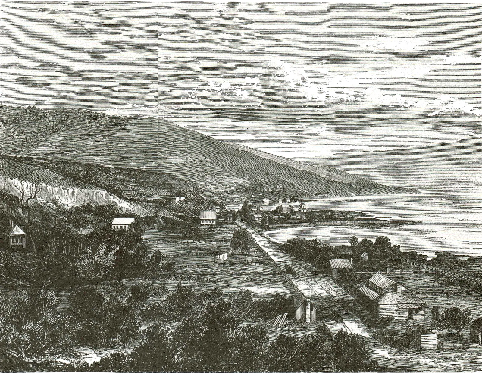
38. Akaroa (1871)
Founded by French settlers in 1840, the town had become a popular tourist resort by the 1870s. The Illustrated Australian News commented thus: ‘Possessed of a lovely climate, and surrounded by beautiful scenery, Akaroa is one of the pleasantest summer retreats for the hard-worked merchants and tradesmen of Christchurch and Dunedin, by whom and their families it is annually crowded.’ The sea voyage from Dunedin added to the enjoyment of the vacation.
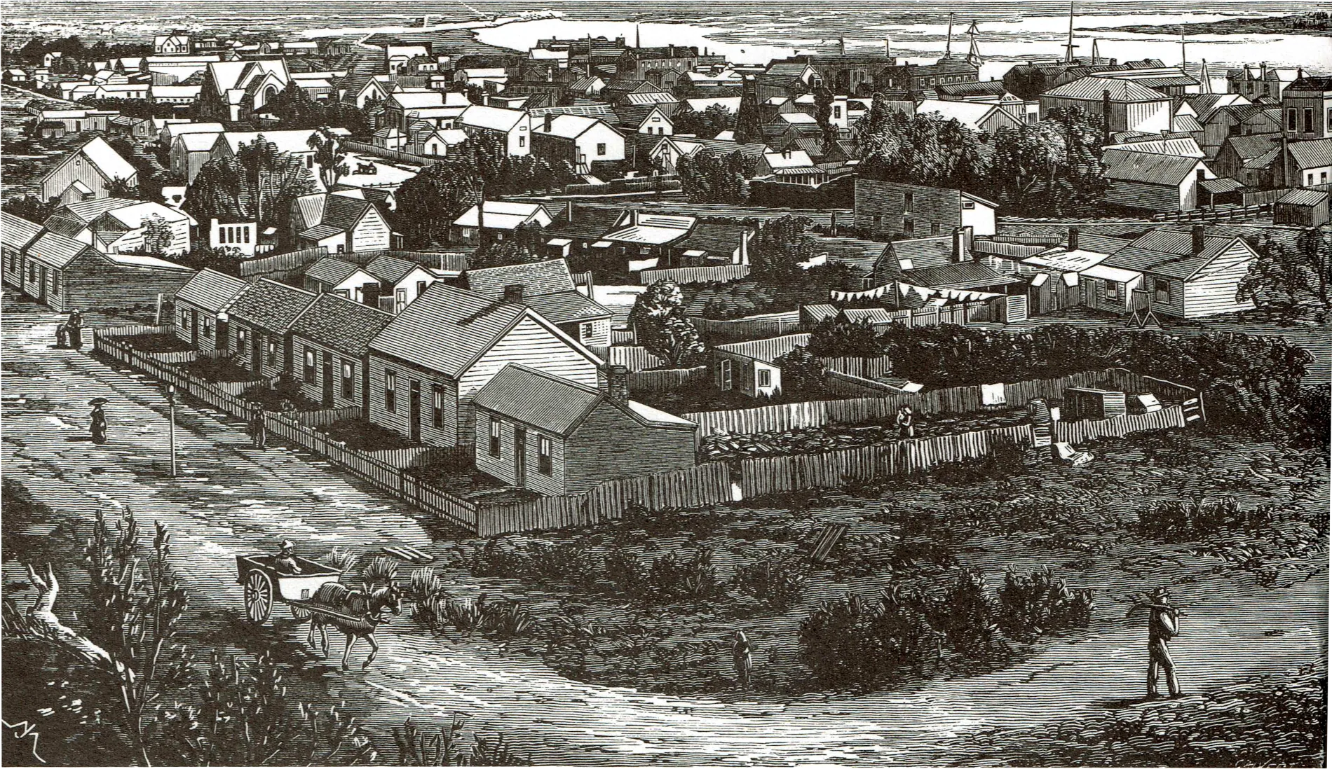
39. Kaiapoi (1878)
Situated on the banks of the Waimakariri River, Kaiapoi had in the late 1850s and 1860s seemed destined to become a major centre because of its function as a river port. Development had been hindered in the 1860s, however, by a series of devastating floods, which forced the Provincial Council to undertake flood protection works. In 1878 it seemed to be on the point of further growth, as in that year the Kaiapoi Woollen Factory was established. The engraving shows the town as seen from near the Railway Station.
40. Revell Street, Hokitika (1881)
‘The feature which most startles a visitor to Hokitika is the extraordinary number of places for the sale of drink. Revell-street, with its grog shanties and bar-gifls, has not its fellow in New Zealand, nor probably in Australia — at least in any settled town. At every few steps you pass a liquor saloon, sometimes three or four in unbroken row.’ Such was the reaction of a liberal-minded Wesleyan (later Anglican) minister, the Rev. A.R. Fitchett, in 1875.
41. Greymouth (1885)
Built on the southern bank of the Grey River, Greymouth in the ’eighties was still essentially a mining town. One curious custom a tourist noted in 1893 was that ‘all through the night the watchman at intervals calls out the time and the state of the weather’ — a custom that was unique in New Zealand and which had disap- peared from the European cities where it had originated.
42. Nelson (1877)
Known far and wide as ‘Sleepy Hollow’, Nelson was nevertheless envied for her ‘glorious climate, cloudless sky, pleasant drives, and sylvan retreats.’ Being the main town of New Zealand’s hop-growing district, Nelson in the 1870s was famous for its ale, supporting three breweries. The engraving was taken from a photograph by the English and Continental Photographic Company — of Nelson!
43. A Distant View of Wellington (1869)
Based on a sketch by the artist Nicholas Chevalier, the engraving gives an unfamiliar view of Wellington in the late 1860s. The scenery around Wellington was described as ‘bold and picturesque’ though ‘the situation is considered to be rather windy.’ An early inhabitant was more forthright. Writing in 1842 Matilda Blake stated: ‘As to churches and chapels, there is not one built here yet, the people are afraid the devil will blow them down here, as the place is called the Devil’s Bellows, so they say prayers in buildings hired for the purpose.’
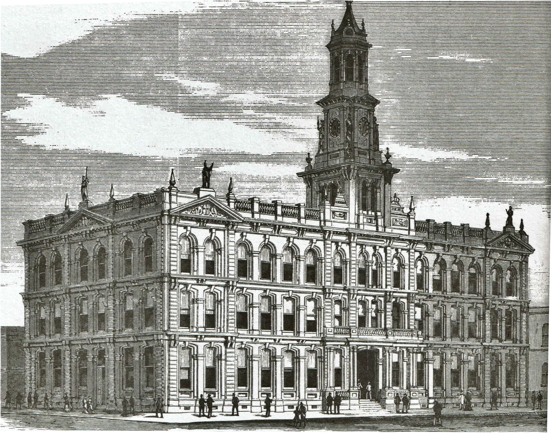
44. New Post and Telegraph Office, Wellington (1880)
An engraving of the prize design of Mr Thomas Turnbull for the new building fronting on Customhouse Quay.
45. Wellington (1884)
Succeeding Auckland as the capital of New Zealand in 1864, Wellington was very much a government city. At centre right is the large wooden Government Building, and facing it (with tower) is Parliament Building. Because of fear of earthquakes most houses and many commercial buildings were constructed of wood.
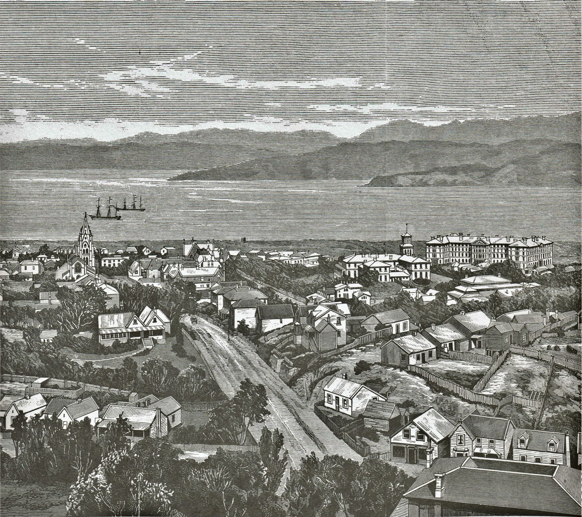
46. Wanganui (1869)
Although founded as early as 1841 as an offshoot of the Wellington settlement, the town had witnessed only slow growth, its 1867 population being a little over 2,000. The river was not bridged until 1871. The view is from Durie Hill with Victoria Avenue at right.
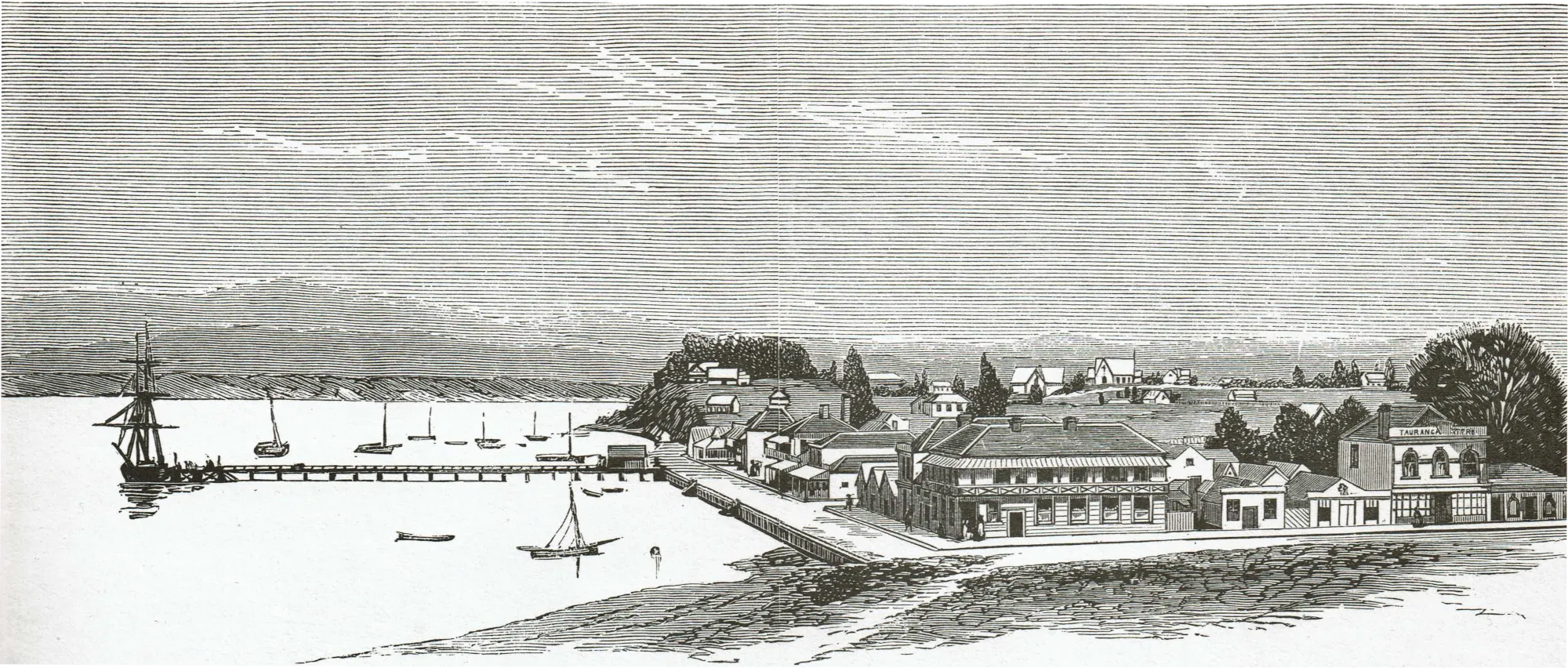
47. Tauranga (1876)
Originally a Mission station, Tauranga in the 1870s occupied a significant position as the starting off place for coach trips to the ‘Hot Lakes’ of Rotorua. Described as ‘accessible to the largest vessels’ and ‘affording shelter from every wind’ the harbour offered the only protected anchorage between Auckland and Wellington via the East Coast.
48. Napier (1875)
The capital of the Province of Hawke’s Bay, Napier boasted a population of about 3,000 in 1875 Its prosperity was based largely on the sheep runs which occupied the fertile Ahuriri Plains shown in the background of the engraving, as well as the hill country further inland.
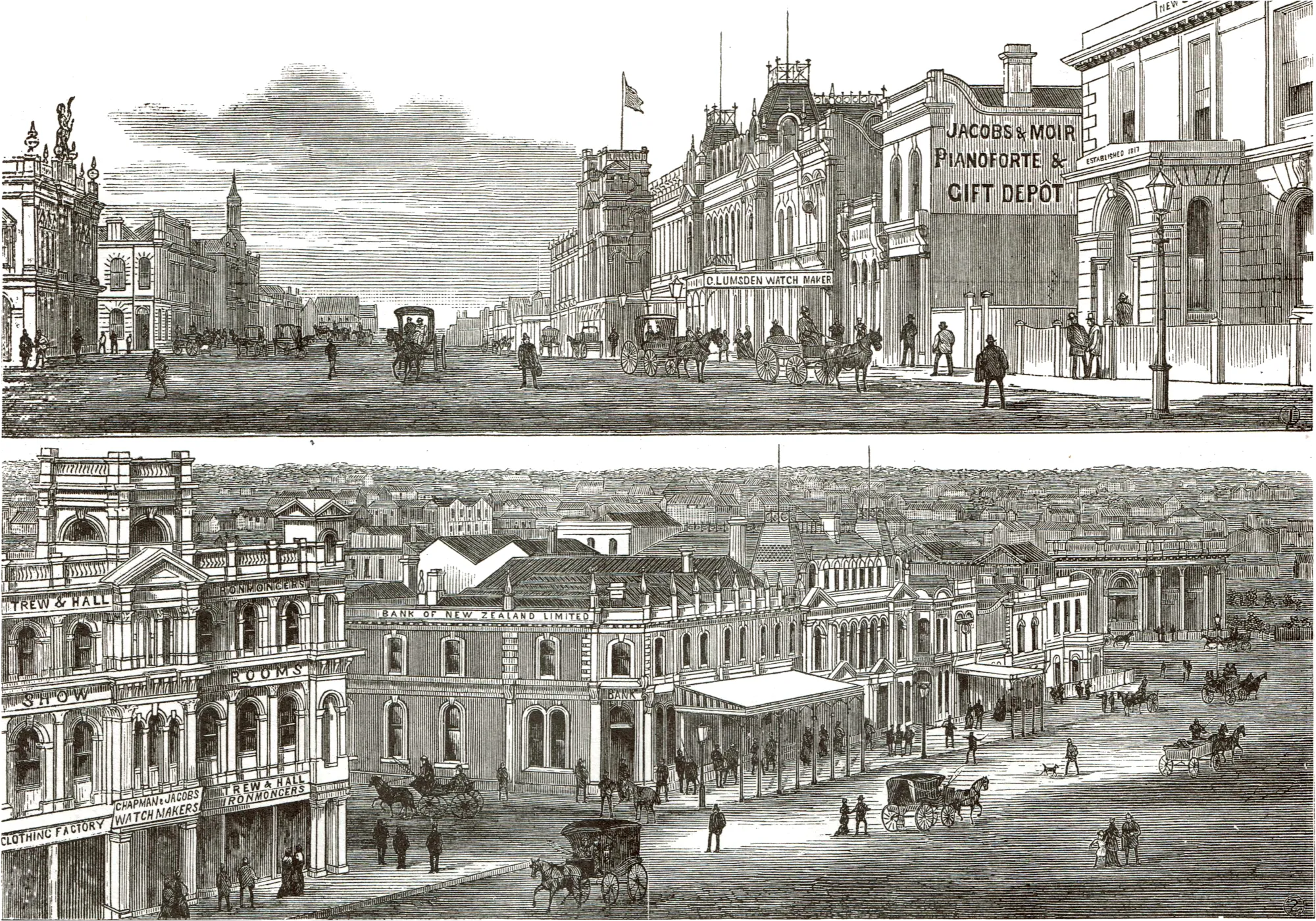
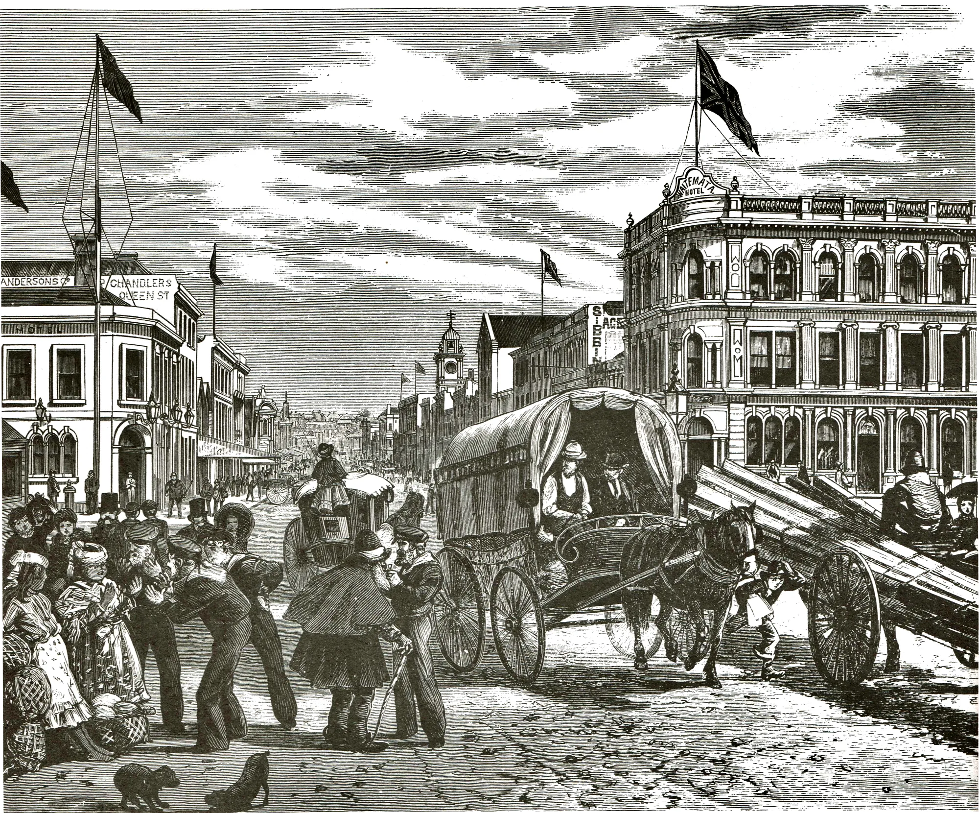
49. Queen Street, Auckland (1883)
The centre of Auckland business and finance, Queen Street terminated its northern end on the city’s longest wharf, which stretched 517 metres (1,696 feet) out into the Waitemata Harbour. In the left foreground are a number of ‘Jacks’ bargaining for water melons with two gaily-dressed women, while at right a newsboy dodges nimbly between horse and waggon.
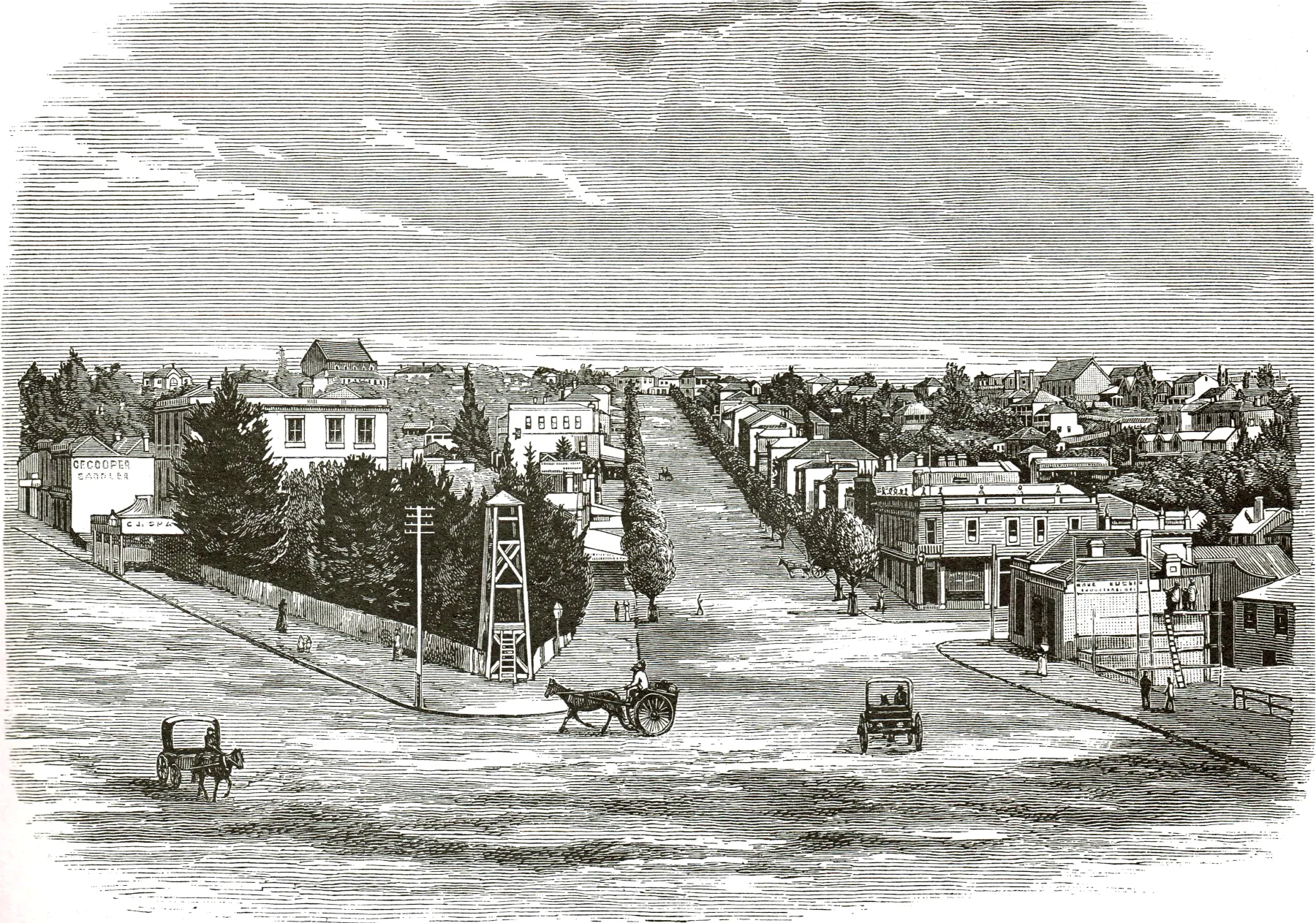
50. Grey Street, Auckland (1884)
Now known as Grey’s Avenue, this street was the site of one of the earliest attempts in Auckland to improve the visual appearance by the planting of trees. Mooted first in 1873, the planting programme finally got under way four years later. The land behind the fire bell is now occupied by the city’s town hall.
51. The Ups and Downs of Life (1873)
Why did I put this in section 2?
Move to News of the Day?
A comment from the National Punch published in Auckland, on the problems faced by urban dwellers before cities and towns formally declared street levels.
52. Russell (1885)
Originally known as Kororareka, meaning ‘tasty blue penguin’, the town could claim to be the oldest urban settlement in New Zealand having been founded well before the Treaty of Waitangi was signed. Although the capital of New Zealand from early 1840 to March 1841, once the seat of government was moved to Auckland the town languished, and in 1885 could claim a population of only about 300 inhabitants.
In this segment we take a look at 26 different illustrations which accompanied some of the biggest news stories between the 1860’s and 1880’s. From fires, to floods and all the way to religious riots, let’s take a look back these big stories.
1. Great Fire at Lyttelton (1870)
The ‘Great Fire’ at Lyttelton of 25 October 1870 started in the Queen’s Hotel, raged for some four hours, and destroyed the entire block of buildings surrounded by London, Oxford, and Canterbury Streets and Norwich Quay. The lack of an efficient local fire brigade contributed to the disaster and it was only after firemen and their equipment were conveyed by special train from Christchurch that the fire was brought under control. Damage was estimated at £80,000, a very large sum in those days. Few New Zealand towns in the nineteenth century escaped serious fires at some time during their growth. Just three years later a major fire in Auckland destroyed 54 shops, factories and houses.
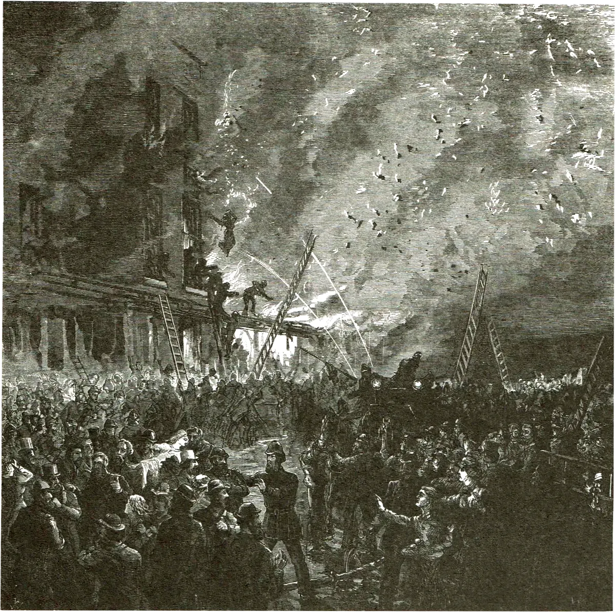
2. Fatal Fire in Dunedin (1879)
At 2.30 a.m. on 8 September 1879, fire broke out in Ross’s Buildings in the Octagon, Dunedin. (The site is now occupied by the Regent Theatre.) The brick building, four stories high at the rear and three fronting the street, proved a fire-trap for the many sleeping upstairs. As graphically shown in the engraving, some of the tenants escaped by ladders, others by jumping into blankets held by rescuers, but 12 people died as a result of the fire. Although arson was suspected and one of the occupants, William Waters, arrested and tried for murder, the accused was found ‘Not Guilty’. This was an unpopular verdict.
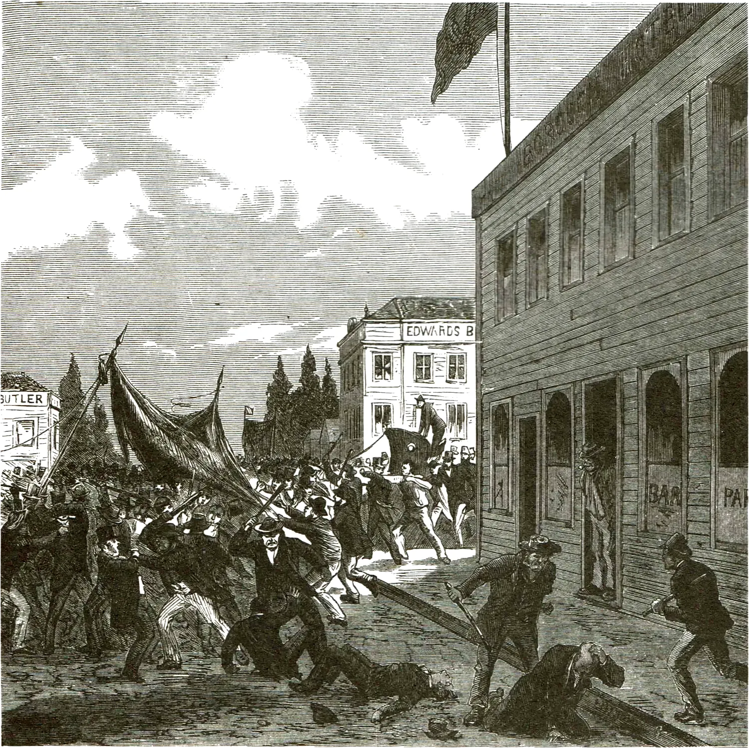
3. Riots at Christchurch (1880)
In December 1879, some 100 members of the Orange Society assembled and, pre- ceded by a band, began to march to Prebbleton. Outside Barrett’s Hotel at the junction of Gloucester and Manchester Streets a brawl erupted which reflected the traditional hostility between the two Irish religious factions, the Protestants and Roman Catholics. Barrett’s Hotel later required a guard to prevent its being wrecked. A similar riot took place in Timaru on Boxing Day.
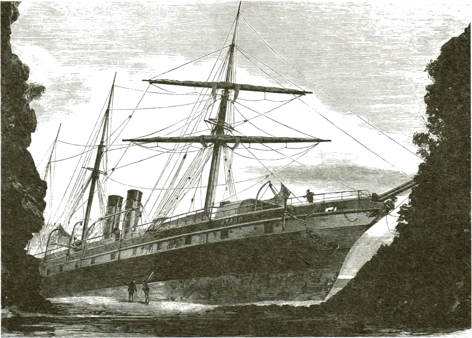
4. Otago on the Rocks (1877)
Sea travel round New Zealand was a hazardous adventure last century, and many vessels were lost. The steamship Otago, on a voyage from Dunedin to Melbourne, was wrecked on 4 December 1876 on Chasland’s Mistake, a point 66km (41 miles) northeast of Bluff. The 2nd mate, who was on watch at the time of the mishap, was subsequently found to have been at fault, having failed to keep the vessel on its proper course, or to have taken the accepted precautions when the vessel was close to the coast in foggy weather. His certificate was suspended for two years.
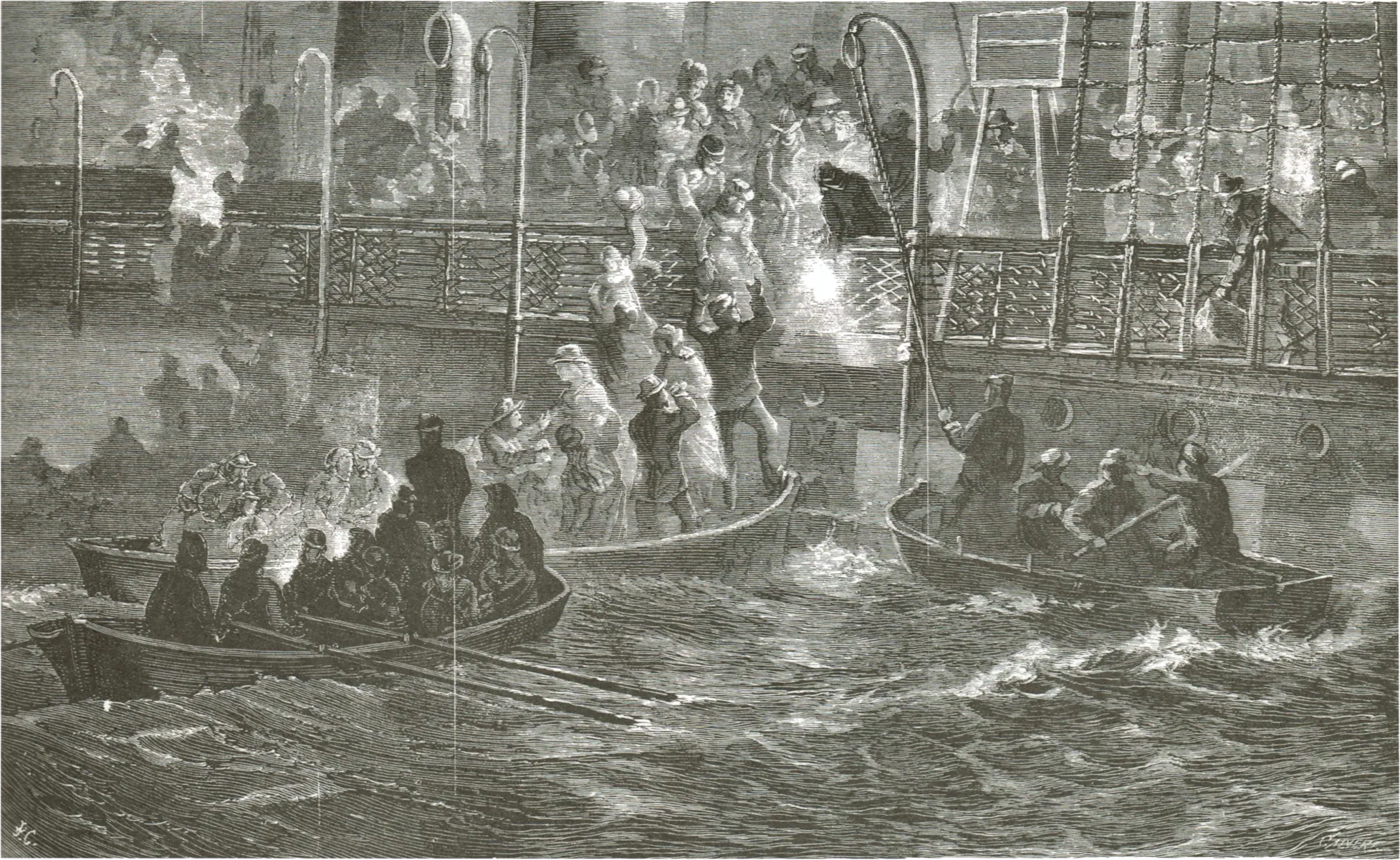
5. Rescuing Passengers off the Otago (1877)
All the Otago’s passengers and crew were rescued and some 3,000 oz of gold on board saved, together with luggage and mail. Although the engraving suggests the vessel was on fire, the artist has in fact attempted to show the fog which enveloped the vessel at the time of its grounding. Ten minutes after the Otago had struck the atmosphere cleared.
6. Wreck of the Tararua (1881)
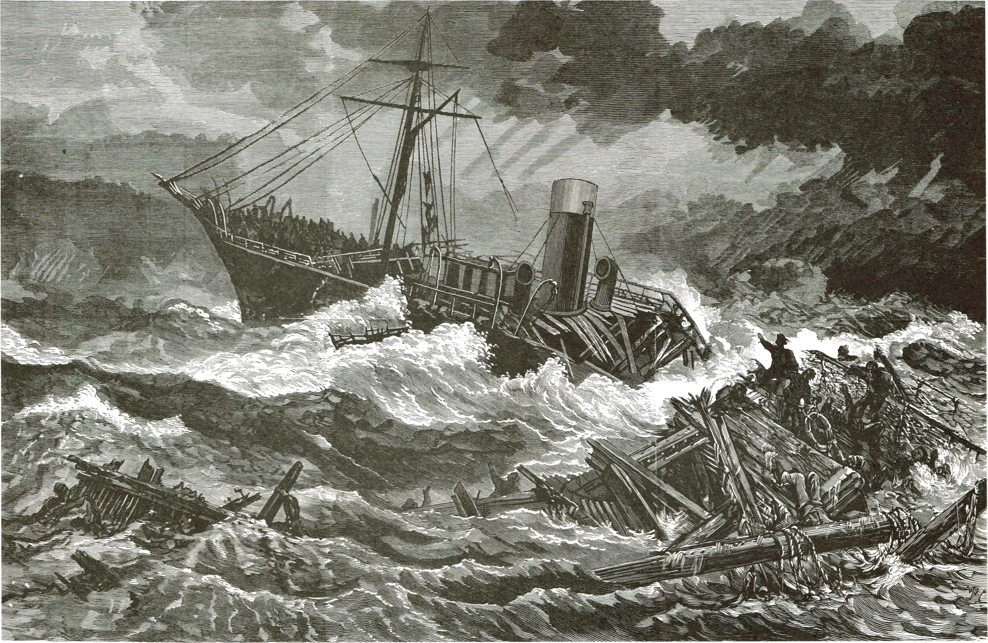
One of the most tragic wrecks in New Zealand’s history was that of the steamship Tararua off Waipapa Point, Southland, on 29 April 1881, The wreck was the result of the negligence of Captain F,G, Garrard in failing to correctly ascertain the Tararua’s position an hour before she ran on to Otara reef, The vessel struck at 5 a.m., but all attempts to get a line ashore failed, At 2 p.m. on the same day the Tararua began to break up, as depicted in the engraving. Many of the survivors huddled in the fore-part of the vessel, and signs of life could be observed on board until shortly after 2,30 a.m, on 30 April, Help from Dunedin arrived too late, and of the 151 on board, 131 perished.
7. Lawrence’s Swim Ashore (1881)
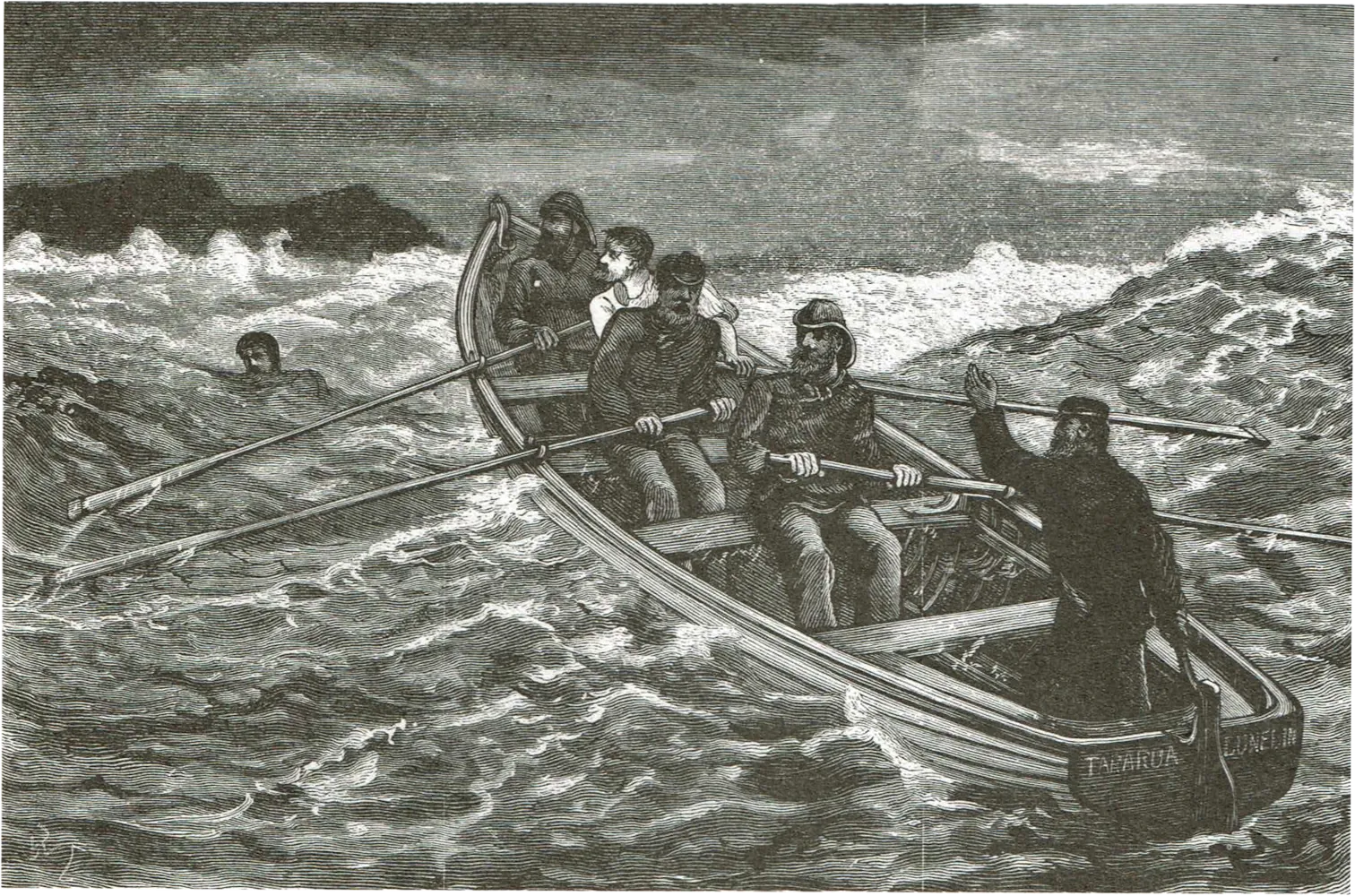
Shortly after the Tararua struck, a life boat with five crew members and a passenger, G. Lawrence, attempted to get ashore. Lawrence bravely swam half the distance and gave the news of the wreck to a settler, who then rode 56km (35 miles) to Wyndham to raise the alarm. The life boat returned to the stricken Tararua.
8. Wrecks at Timaru (1882)
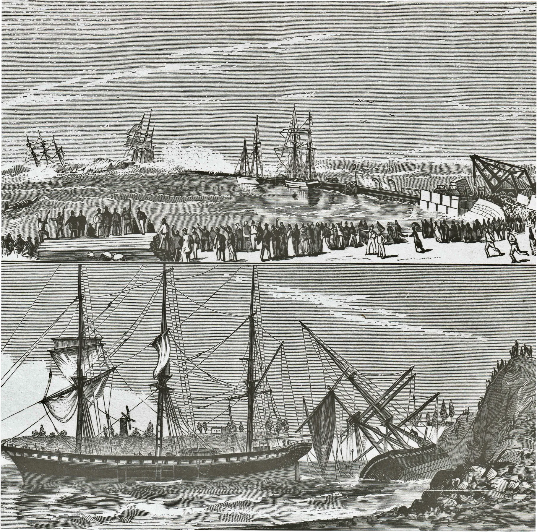
Heavy seas at Timaru Sunday 14 May 1882 caused the grounding of two vessels, the Ben Venue and the City of Perth. The cargo of coal carried by the former vessel shifted in the heavy swell, causing her to list, and eventually to break loose from her moorings and drift broadside on to the cliffs where she capsized and became a total wreck. Her crew had already abandoned her, havaing taken refuge on the City of Perth, but when this vessel also broke loose both crews took to the boats. An attempt at salvage by the Timaru harbourmaster ended in tragedy when three small boats were swamped and seven men drowned. All these events took place in view of crowds of onloookers lining the high ground overlooking the port. The City of Perth whic had drifted ashore alongside the Ben Venue remained upright and was later refloated
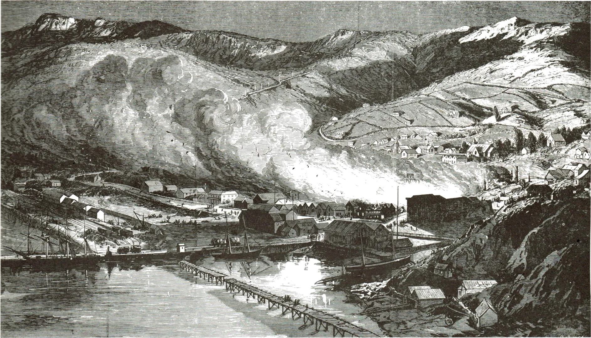
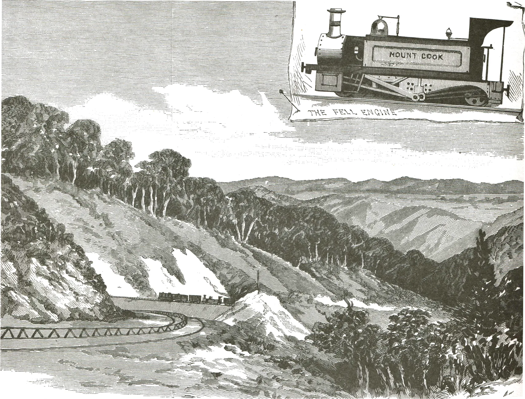
9. Eastern Side of The Rimutaka Incline (1880)
The railway crossing the steep Rimutaka Ranges between Wellington and the Wairarapa needed special Fell locomotives (inset) to provide the motive power, for grades on the east averaged 1 in 15. Beside the normal driving engine, Fell locomotives made use of a second engine that drove horizontal wheels which gripped a third centre rail. As can be seen in the engraving this third rail was raised. The rail- way from Wellington to Featherston was opened in October 1878, and to Masterton two years later. Fell locomotives continued to be used on the line until the opening of the Rimutaka tunnel in 1955.
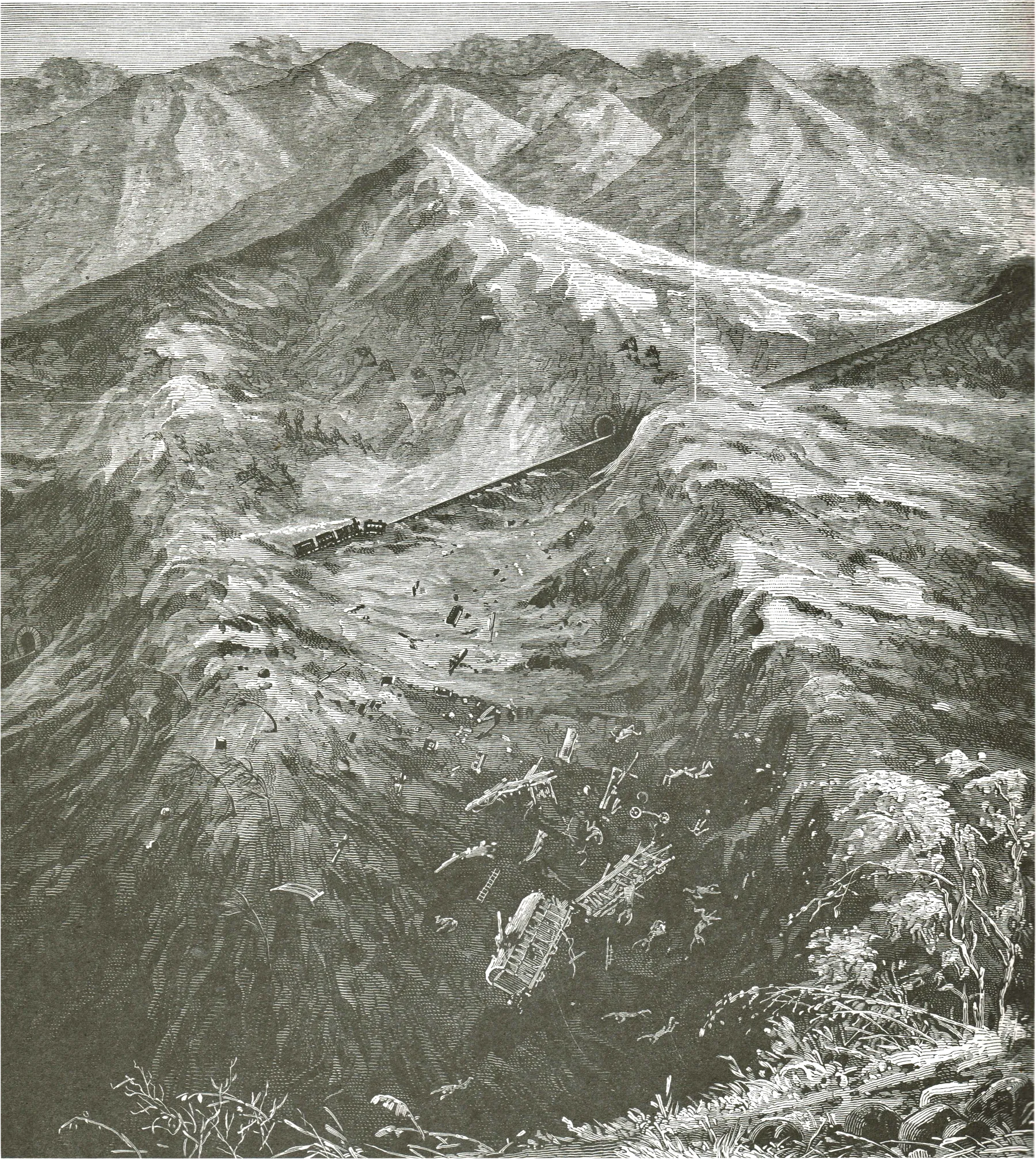
10. Train Blown Off Line (1880)
On 11 September 1880 the morning train to Wellington was blown off the rails at a spot called ‘Siberia’ on the Wairarapa side of the Rimutaka incline. The name ‘Siberia’ had been given to the area because ‘of the violent and piercing blasts’ of wind that swept down here. To assist in the ascent the locomotive was in the middle of the train, and it was the leading two passenger carriages and a van which were blown off the line. The artist’s dramatic drawing of carriages and bodies flying through the air is not a true portrayal of the incident. The couplings held the train together, although the body of the first carriage was torn off and the passengers thrown out. Unfortunately three children were killed and 11 adults injured.
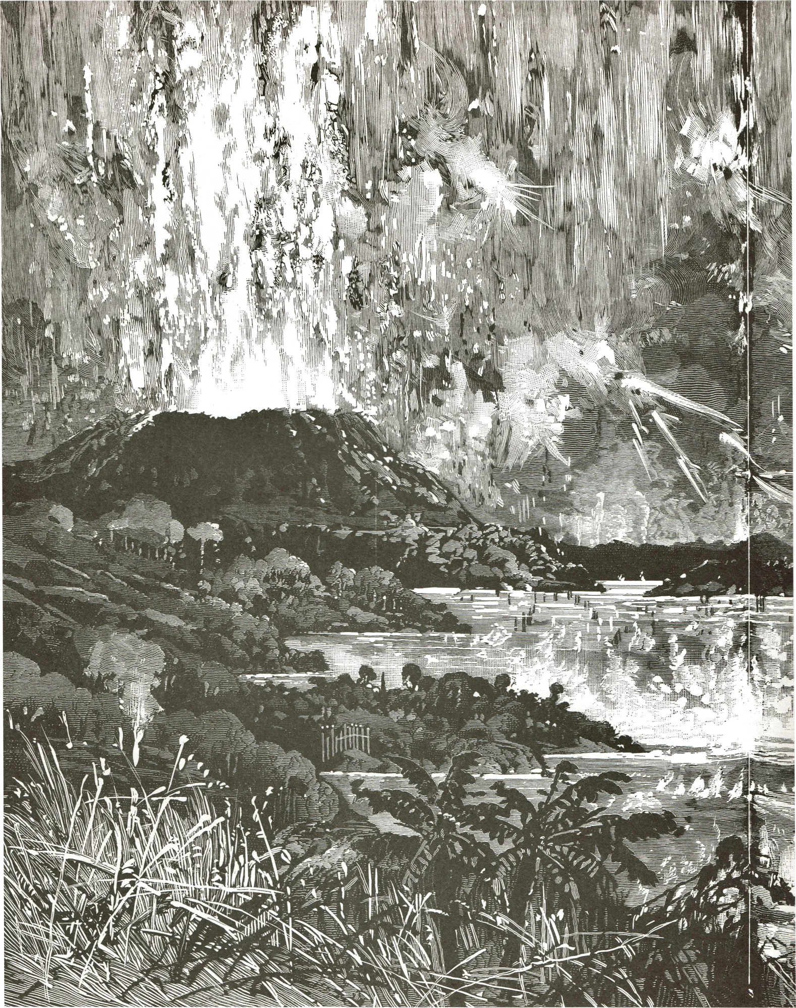
11. The Eruption of Mt Tarawera (1886)
In the early hours of 10 June 1886 Mt Tarawera erupted with great violence, and the artist has attempted to do full justice to this catastrophic event. During the six hours of the eruption, which was accompanied by earthquakes, the world famous Pink and White Terraces were destroyed, and an estimated 153 people killed, all but six being Maoris.
12. Results of the Eruption (1886)
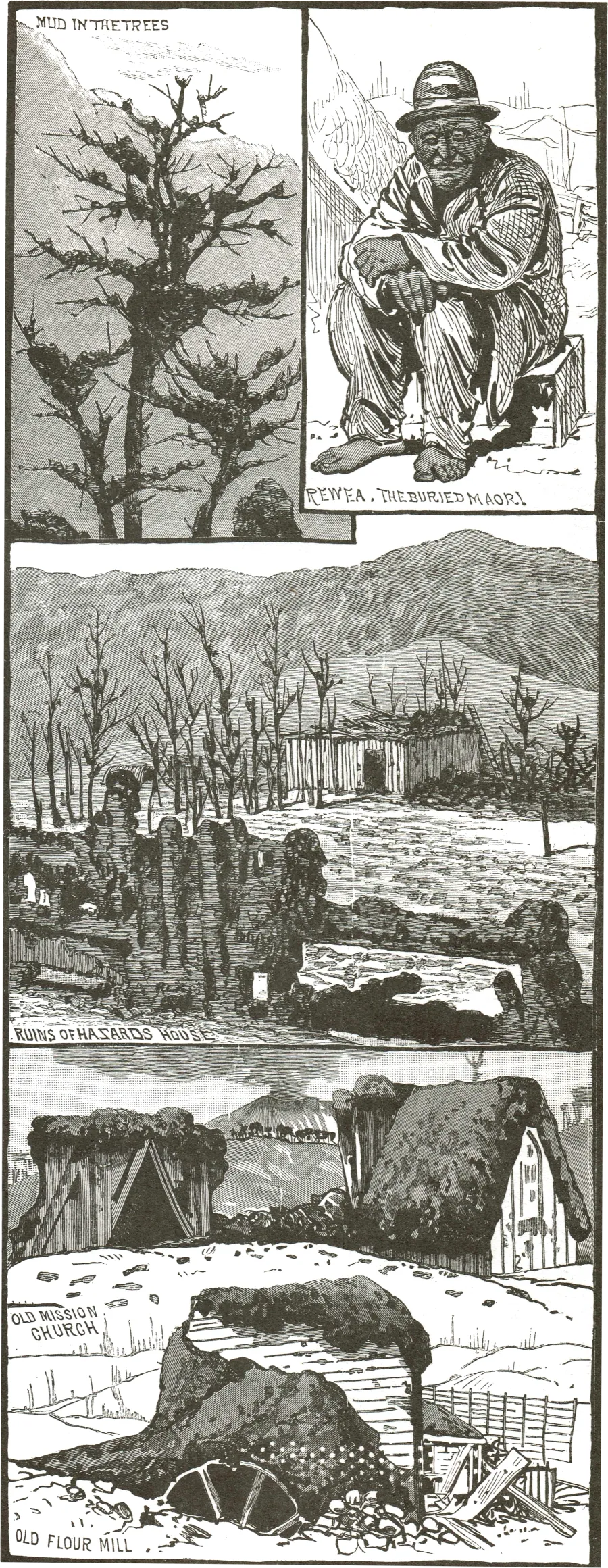
Ash and debris from the eruption were scattered over thousands of square kilo- metres, though greatest destruction of property occurred in the immediate vicinity. Three Maori villages were destroyed, and the roofs of the few European buildings in the area, such as that of the schoolmaster Charles Haszard, caved in with the weight of the ash. The Maori shown at top right was Rewea, reputed to be 106 years old, who was reported to have been buried in his whare for several days before being rescued. Unfortunately he died shortly after.
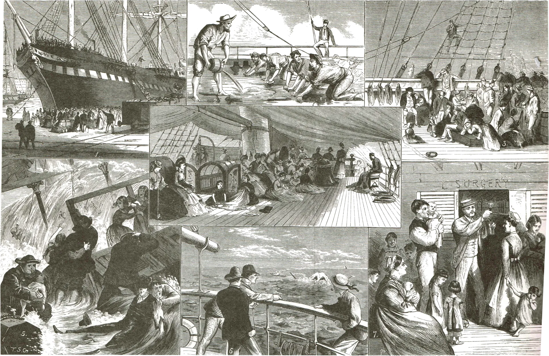
13. Sketches on Board an Immigrant Ship (1875)
The 1870s were a major period of immigration inflow into New Zealand, with some 140,000 people arriving over the years 1870 to 1881. Events of the long sea voyage — perhaps three months or more — shown in the engraving include the departure from London; scrubbing the decks with sandstone, or ‘holystoning’; life on the decks in good weather, and bad; catching an albatross; and getting what was called ‘medical comforts’, namely a glass of port wine or brandy.
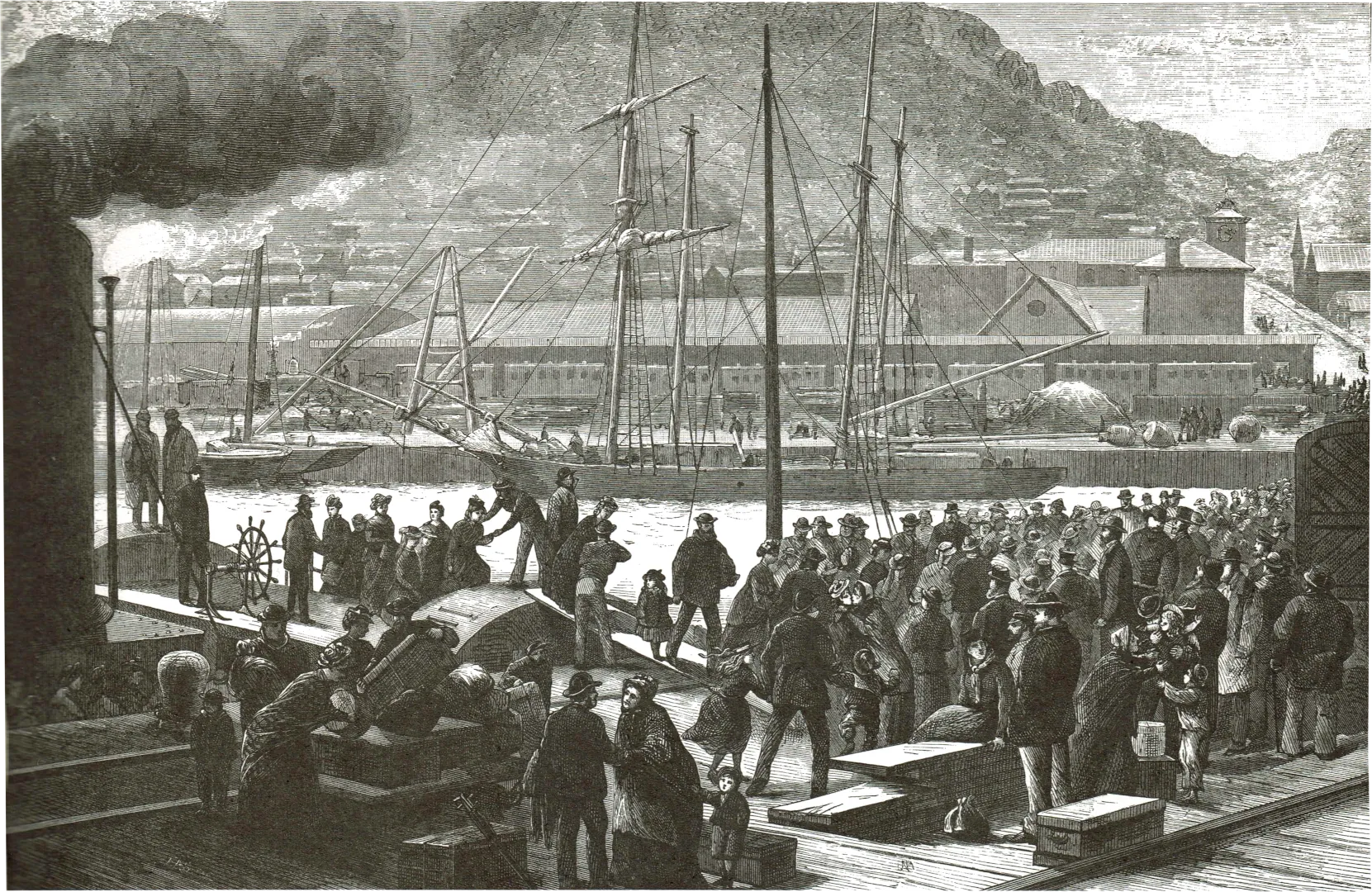
14. Immigrants Landing at Lyttelton (1877)
The 1870s were a major period of immigration inflow into New Zealand, with some 140,000 people arriving over the years 1870 to 1881. Events of the long sea voyage — perhaps three months or more — shown in the engraving include the departure from London; scrubbing the decks with sandstone, or ‘holystoning’; life on the decks in good weather, and bad; catching an albatross; and getting what was called ‘medical comforts’, namely a glass of port wine or brandy.
15. Turuturumokai Redoubt (1868)
Despite its solid-looking appearance in the engraving, Turuturumokai Redoubt (near present-day Hawera) was undergoing repairs and strengthening when attacked by some 60 Hauhaus on 12 July 1868. Of the 20 European defenders, ten were killed and six wounded, but even so the Maori attackers were held at bay until a relief party arrived and saved the survivit defenders.
16. Mt. Egmont and Redoubt (1869)
Throughout the 1860s Taranaki suffered from war and threats of war, and redoubts were built in a number of locations. The redoubt at Turuturumokai had been built in 1866 by the 18th Royal Irish Regiment, but was poorly sited, its interior being open to fire from nearby higher ground.
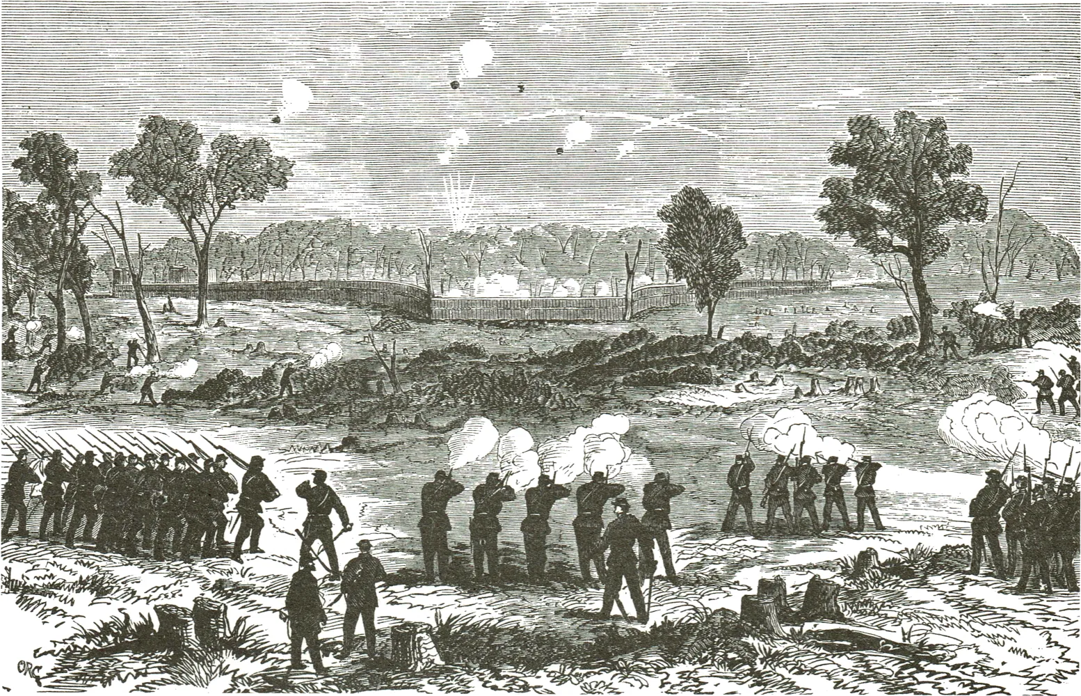
17. Assault on Nukumaru Pa (1869)
This pa at Tauranga-ika, some 29km (18 miles) from Wanganui, was a well-designed fortification occupying a strategic position on the edge of an almost trackless forest. Colonel G.S. Whitmore, with a mixed force of Armed Constabulary, Volunteers, and Wanganui Maoris fired on the pa on 2 February 1869, the Hauhau defenders vigorously responding. The next day the attacking force cautiously advanced on the pa, only to find it abandoned.
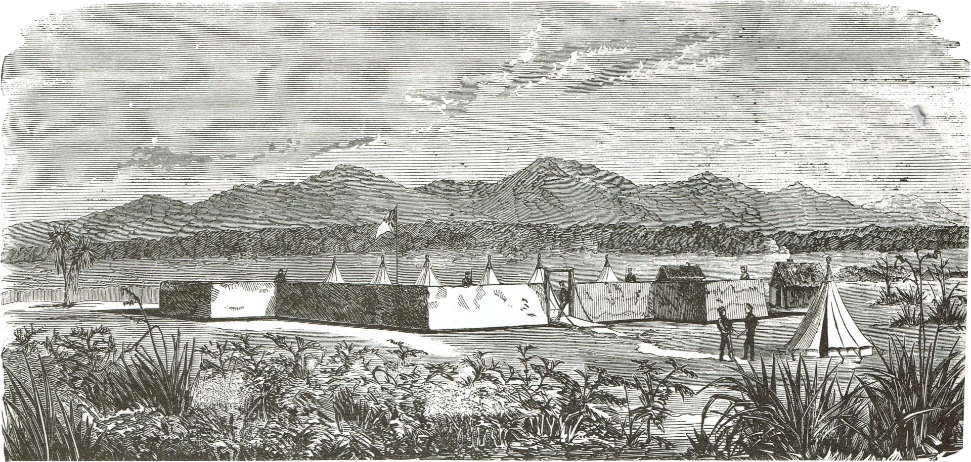
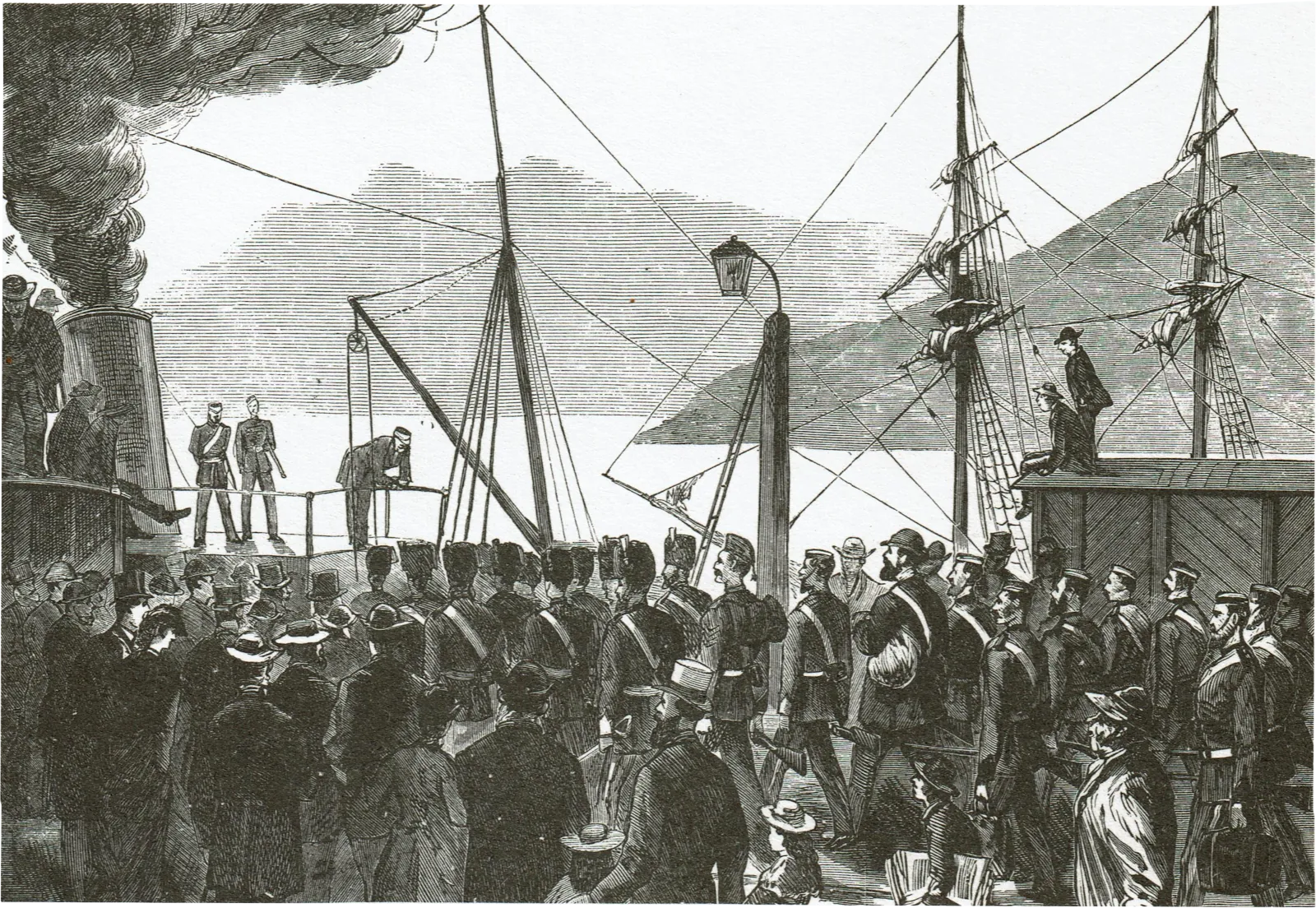
18. Departure of Timaru Volunteers for Parihaka (1879)
By 1872 the Maori Wars were largely over. However, disputes over land and the confiscation policy continued to engender bitterness and distrust. In the late 1870s the biblical prophet and pacifist, Te Whiti, opposed Government attempts to have the Waimate Plains in Taranaki surveyed and opened for settlement, for although confiscated in 1865, the land had never been occupied by the European, and the Maori considered the land still his. Soldiers were used to prevent Te Whiti’s followers halting surveys and ploughing settlers’ pasture. The final government response to the continued peaceful opposition of Te Whiti was to send militia to his settlement at Parihaka. Te Whiti was arrested on 5 November 1881 and his followers dispersed. From the background of the engraving, we may assume that the Timaru Volunteers embarked at Lyttelton.
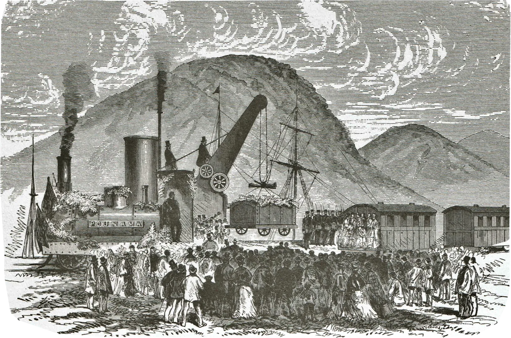
19. Hoisting the First Truck of Coals, Greymouth-Brunner Railway (1876)
The 11km (seven mile) railway along the Grey Valley, Westland, was formally opened on 7 April 1876. Greymouth celebrated the occasion with a procession of school children and friendly societies, a luncheon, and a ball. West Coast coal was in growing demand elsewhere in the Colony and the railway link to the port enabled the Brunner coal to be more easily exported. The length of track is now part of the Midland Line between the West Coast and Canterbury.
20. Balclutha Under Water (1878)
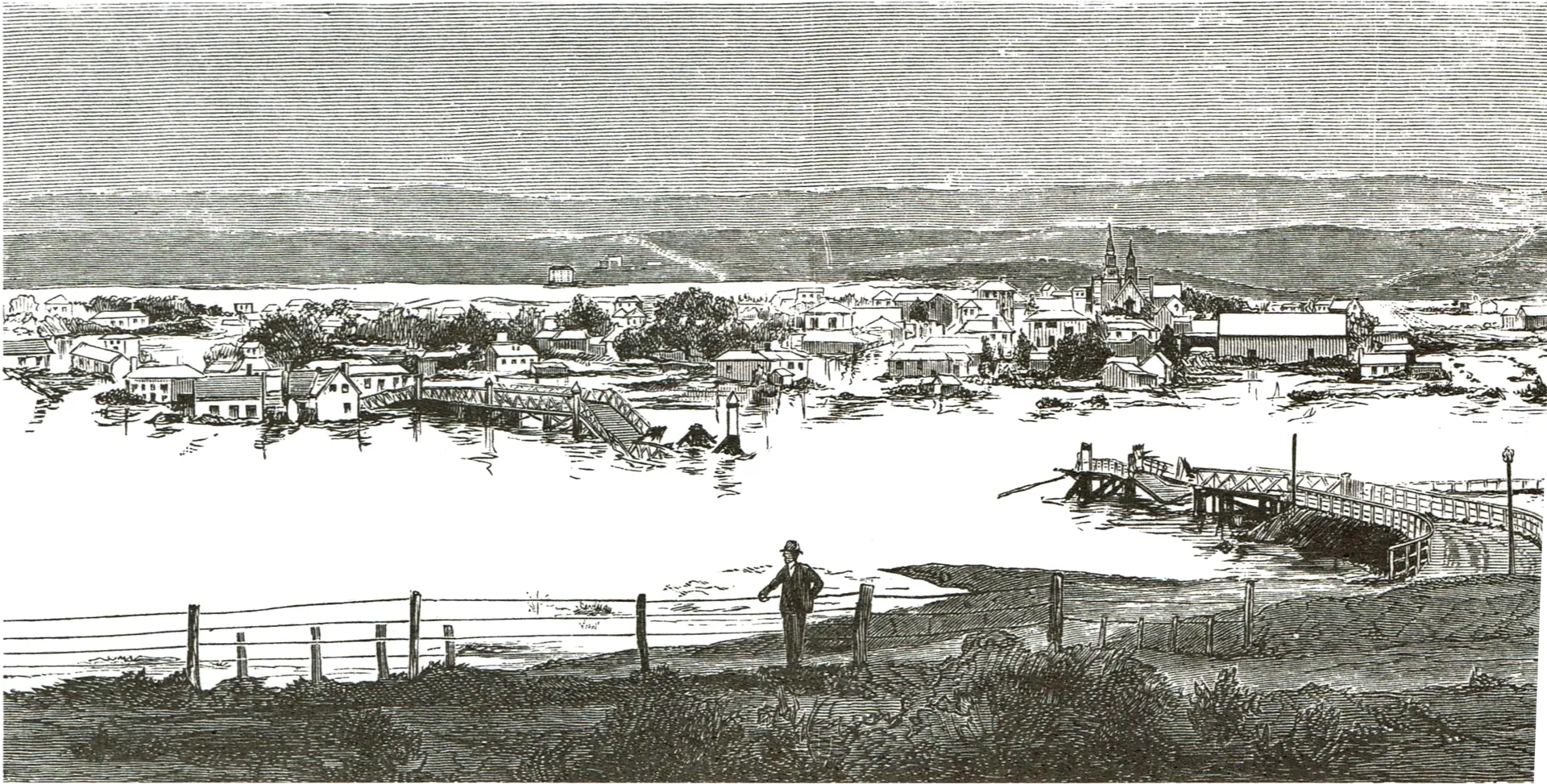
The floods in Central Otago in 1878 were among the worst in New Zealand’s history. A long severe winter which left snow lying up t 30.5 metres (100 feet) thick, was followed by warm wi and rains in September. By the end of that month all the rivers and streams of Central Otago were in flood, the Clutha reached some 12 metres (40 feet) above normal Cromwell, Balclutha was completely inundated, and th Port of Molyneux left high and dry as the river formed new channel which it has since continued to occupy.
21. Assault on Mt Cook (1882)
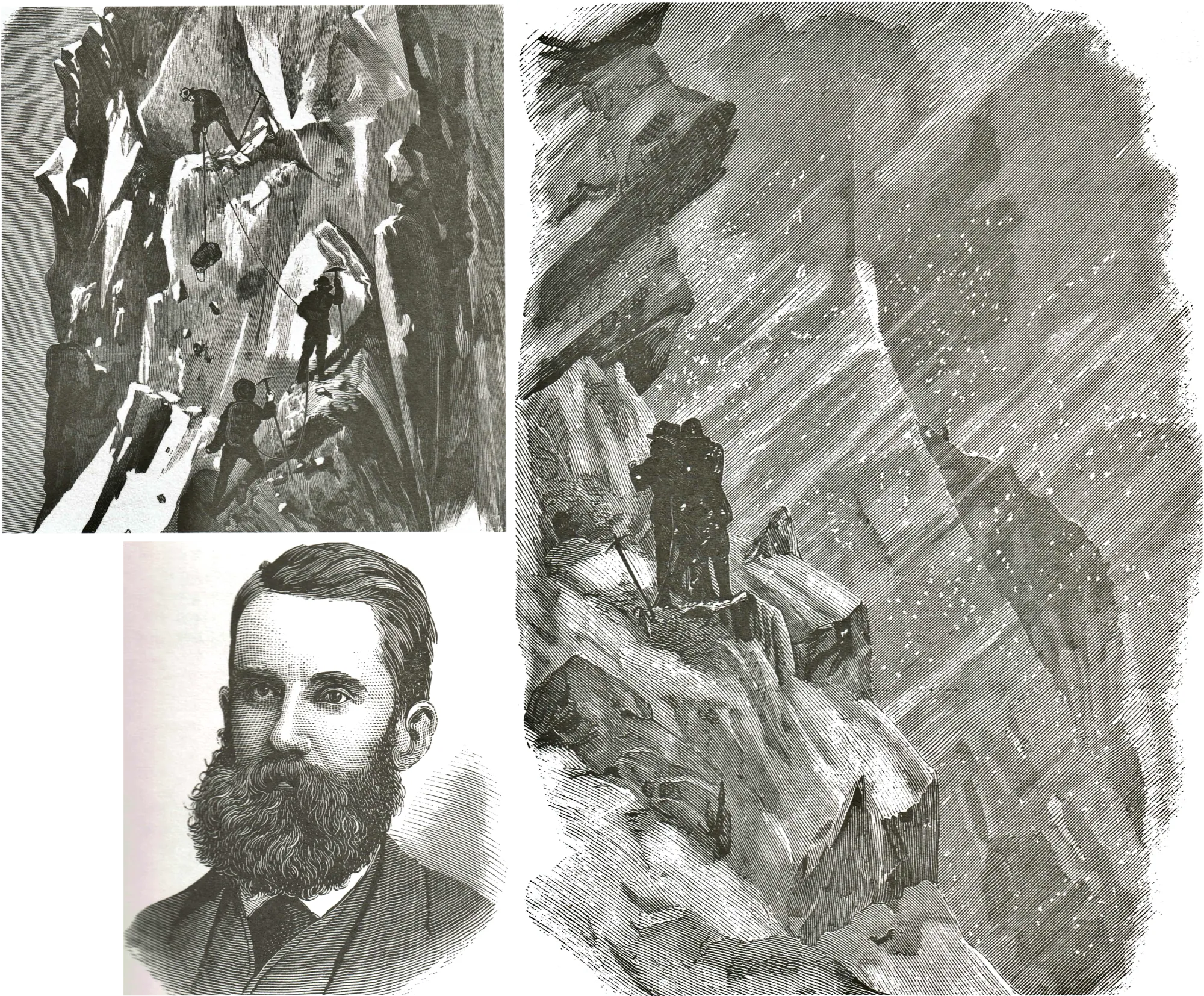
In the latter quarter of the nineteenth century the magnificent mountain ranges of the South Island attracted experienced climbers from overseas. An Irishman, the Rev. W.S. Green, (image 1) together with two Swiss guides made three attempts on Mt Cook in 1882. Based on Green’s own sketches, the second engraving (image 2) shows the party on its unsuccessful attempt to ascend by the eastern ridge, and the third engraving (image 3) the party ‘benighted’ on a ledge of rock some 46cm (18 inches) wide. This latter event occurred on their descent after the three men had reached the highest ridge about 61 metres (200 feet) from the summit at 6.20 p.m. Mt Cook was finally conquered 12 years later by a party of three New Zealanders, Tom Fyfe, George Graham, and Jack Clarke.
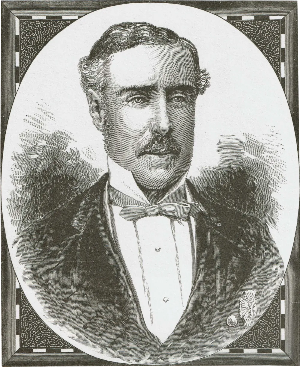
22. Sir George Grey (1878)
Often described in school texts of 30 or more years ago as ‘the great pro-consul’, Sir George Grey was the first person to have served both as Governor and Prime Minister of New Zealand. His two terms as Governor were 1845-53 and 1861-68, and he held the Premiership from 1877 to 1879.
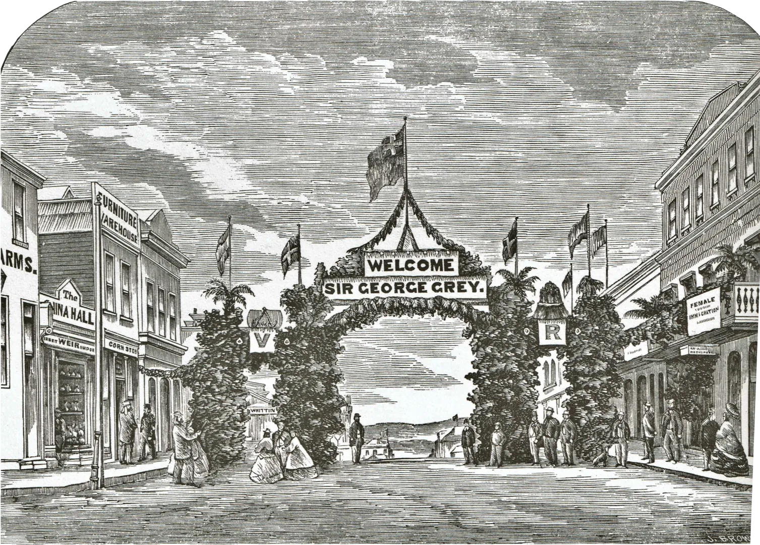
23. Triumphal Arch, Dunedin (1867)
This arch was erected it Princes Street in honour of Sir George Grey’s visit. Arches such as this were erected throughout New Zealand during the nineteenth, and indeed into the early twentieth century, to mark the visit of important persons.
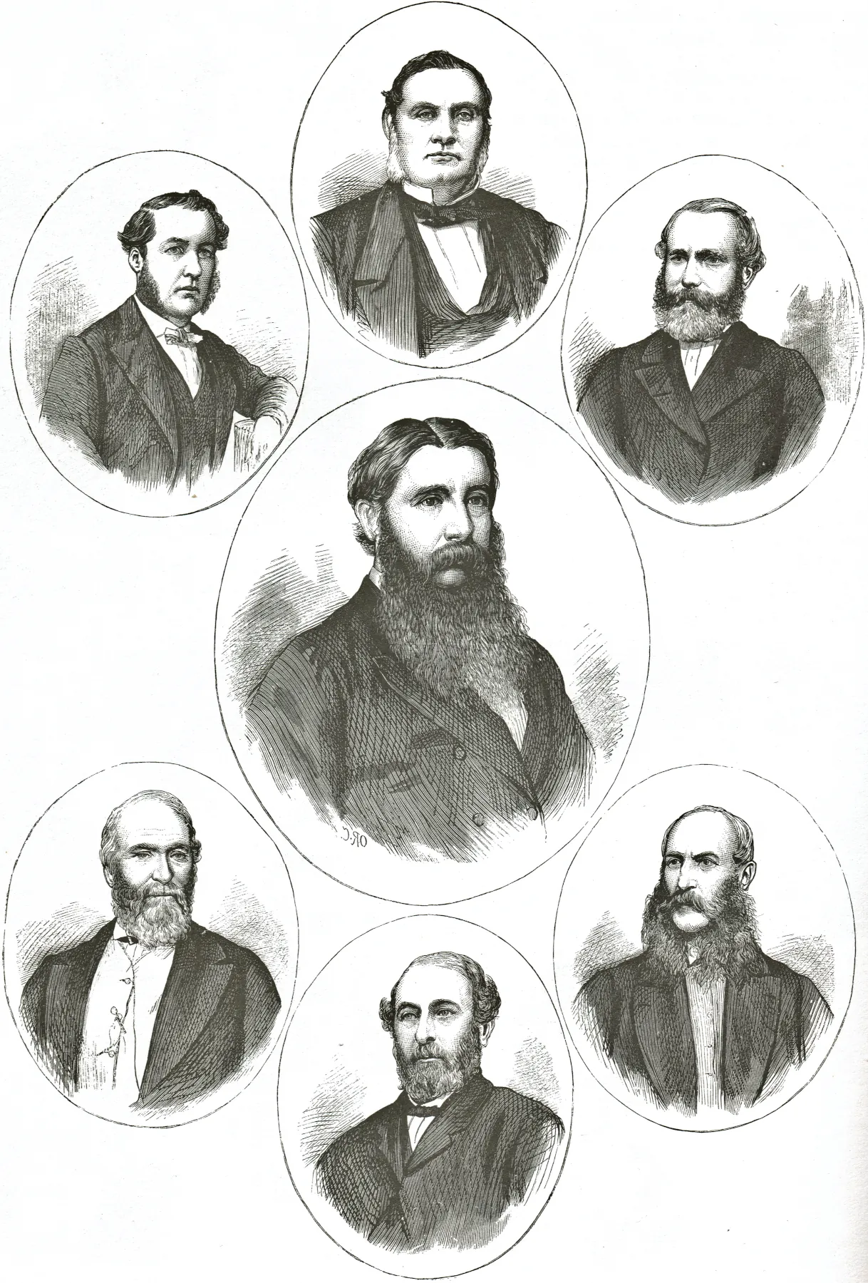
24. The Vogel Ministry (1873)
Politicians, along with senior clergymen, actors and actresses, and notorious criminals, were popular subjects for the illustrated papers of Victoria times. Shown here is the Ministry of Sir Julius Vogel (centre) Clockwise from top left: Edward Richardson, Donald McLean, G.M. O’Rorke, Daniel Pollen, W.H. Reynolds, and John Bathgate.
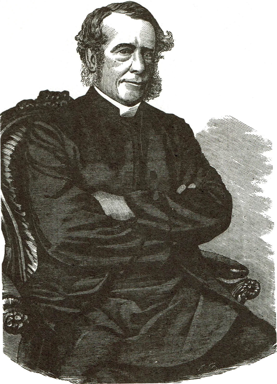
25. Bishop Harper (1867)
In the religious atmosphere of nine- teenth century New Zealand, bishops and other clergymen played an important role in the life of the Colony. Bishop Henry James Chitty Harper, who was the first Anglican Bishop of Christchurch, was a well-known and loved figure throughout his Diocese, which included the goldfields of the West Coast, and for a time Otago and Southland. Harper thrived on the rough life and hardships inseparable from the growth of a new land, and in 1865 when he was 61 years of age, crossed the Southern Alps by foot to visit the West Coast Diggings. Harper succeeded Selwyn as Primate of New Zealand, and in 1893 died aged 89.
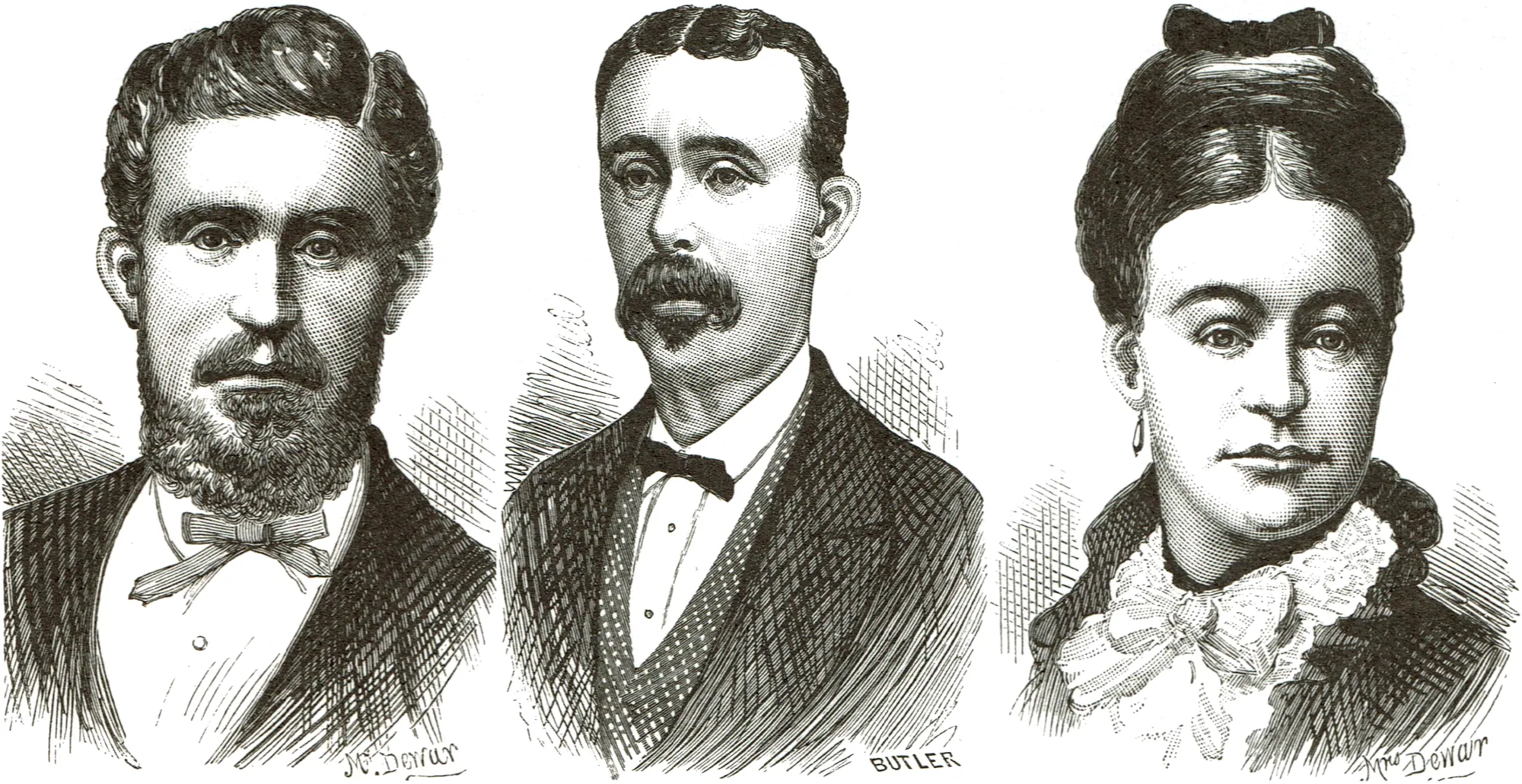
26. Dunedin Murders — the Dewars and Butler (1880)
Created with GIMP
Sinners, as well as saints, provided a continual fascination for Victorians, and full accounts of local murders were printed in newspapers throughout the Colony. In March 1880 Dunedin was thrown into a state of excitement by the brutal murder of James Dewar, his wife, and their baby. Robert Butler (shown in the centre), a confirmed criminal, was arrested near Waikouaiti on suspicion after he had hurriedly left Dunedin. At his trial Butler successfully addressed the jury for six hours in his own defence, and was acquitted. Jailed for 18 years on a separate charge of arson, Butler was eventually hanged in 1905 in Queensland for a murder committed there.